

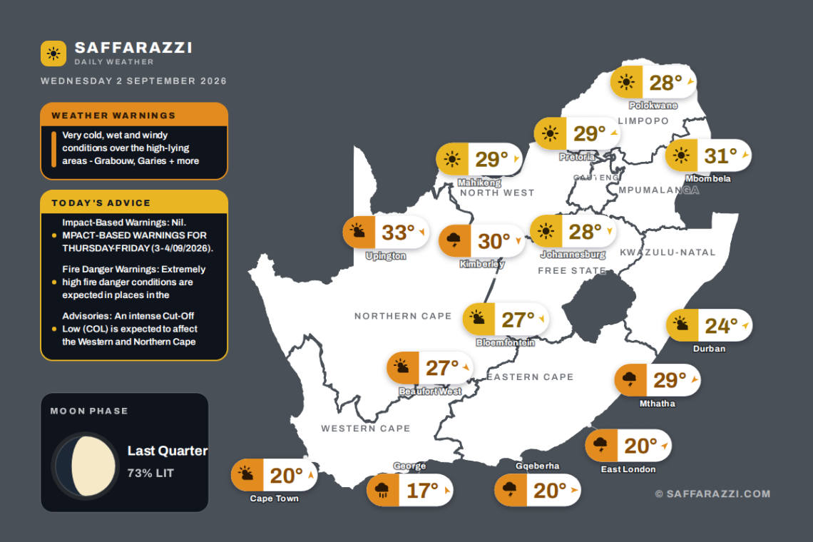

South Africa wakes up to a mix of settled and unsettled conditions this Wednesday, with clear skies and warm afternoons expected across much of the interior, including Johannesburg reaching 28°C, Polokwane 28°C and Mbombela climbing to a balmy 31°C. Showers and thundershowers are on the cards for the Eastern Cape around Gqeberha and the Northern Cape near Kimberley, while Cape Town stays cooler under high-level cloud at 20°C and Durban sits comfortably between 19 and 24°C with partly cloudy skies. Several weather advisories are currently in place from the South African Weather Service, so keep an eye on local updates as the day unfolds.
⚠️ Weather Warnings
Weather Advisory (Warning Advisory), valid until 23:59 on 3 September.
Areas: Grabouw, Garies, Pofadder, Springbok, Worcester, Prince Albert, Knysna, Plettenberg Bay, Paarl, George, Redelinghuys, Swellendam.
- Very cold, wet and windy conditions (with maximum temperatures below 10 °C) over the high-lying areas.
- Disruptive rainfall leading to possible localised flooding over the south-eastern parts of the Western Cape.
- Damaging interior winds as well as gale force winds along the south-west and south coast.
- Damaging waves (reaching 4.5 to 5.5 m in places).
The public and small stock farmers are advised to take the necessary precaution to ensure the safety and health of their animals during very cold days. Limit outdoor activities and keep warm.
Weather Advisories
Impact-Based Warnings
- Nil. MPACT-BASED WARNINGS FOR THURSDAY-FRIDAY (3-4/09/2026).
- Yellow Level 4 Warning: Disruptive Rainfall leading to flooding of roads and settlements, and major disruption of traffic flow are expected over the Overberg and Garden Route District Municipalities in the Western Cape on Thursday.
- Yellow Level 4 Warning: Damaging Wind leading to damage to temporary structures and settlement, injuries and danger to life from flying debris, transport routes and travel services affected is expected over the Namakwa District Municipality in the Northern Cape as well as parts of the Cape Winelands, Central Karoo and the Little Karoo District Municipalities in the Western Cape on Thursday afternoon into Friday.
- Yellow Level 4 Warning: Damaging Wind and Waves leading to disruption of ports/harbours, danger to navigation at sea are expected between Alexander Bay and Plettenburg Bay from Thursday to Friday.
- Yellow Level 2 Warning: Disruptive Rain leading to localised flooding of settlements, roads, low lying areas and bridges is expected in places in places over Koukamma, Kouga and Nelson Mandela Bay Local Municipalities on Thursday.
Fire Danger Warnings
- Extremely high fire danger conditions are expected in places in the Blouberg Local Municipality of Limpopo, most parts of the Northern Cape except the western parts, as well as Mohokare Local Municipality of the Free State.
Advisories
- An intense Cut-Off Low (COL) is expected to affect the Western and Northern Cape provinces from Thursday into Friday (03-04 September 2026). The public and small stock farmers are advised that very cold, wet and windy conditions, as well as disruptive rainfall, damaging interior winds and damaging coastal winds and waves can be expected.
Moon Phase
🌗 Moon phase: Last Quarter: half lit and shrinking – the cycle’s three-quarter mark, a letting-go phase.
The Moon is about 73% illuminated tonight, on day 19.9 of its 29.5-day cycle. It rises at 00:19 and sets at 09:39 (SAST). Next full moon: Saturday 26 September · next new moon: Friday 11 September.
Weather by Province
Gauteng – Johannesburg
11°C to 28°C · clear skies · Rain 0% · light.
Feels like 26°C · humidity 20 to 40% · UV low · wind N at 10 km/h · cloud cover 5%.
SAWS regional outlook: Fine and warm. The expected UVB sunburn index:High.
- Pretoria: 12°C to 29°C · clear skies · wind ENE at 5 km/h
- Soweto: 9°C to 28°C · clear skies · wind N at 10 km/h
- Vereeniging: 11°C to 27°C · clear skies · wind N at 10 km/h
Western Cape – Cape Town
11°C to 20°C · high level clouds · Rain 0% · light Southerly.
Feels like 18°C · humidity 65 to 90% · UV low · wind S at 10 km/h · cloud cover 106%.
SAWS regional outlook: Partly cloudy to cloudy along the southern parts, with misty conditions early in the morning, otherwise partly cloudy to fine and cool to warm. The wind along the coast will be light and variable along the south, but moderate southerly along the west coast, becoming fresh south-easterly in the south-west from the afternoon. The expected UVB sunburn index:Very High.
- Stellenbosch: 3°C to 21°C · high level clouds · wind E at 5 km/h
- Paarl: 6°C to 22°C · high level clouds · wind ESE at 5 km/h
- George: 10°C to 17°C · Slight rain · wind SSE at 10 km/h
KwaZulu-Natal – Durban
19°C to 24°C · partly cloudy · Rain 0% · light South Westerly.
Feels like 23°C · humidity 70 to 85% · UV high · wind SW at 10 km/h · cloud cover 25%.
SAWS regional outlook: Fine to partly cloudy and warm to hot but very hot in the north-east with isolated showers and thundershowers in the south-west. The wind along the coast will be light to moderate northerly to north-easterly, reaching fresh in the north at times, becoming light to moderate southerly to south-westerly from the south. The expected UVB sunburn index:High on X (@SAWeatherServic) OR Facebook (South African Weather Service) We respect your privacy and acknowledge that this email may contain Personally Identifiable Information. The email may belong to you, others, and or to your organization, and which we will process, which processing will be done in accordance with our Privacy Notice on our website – otice.
- Pietermaritzburg: 13°C to 34°C · Showers and Thundershowers · wind NW at 5 km/h
- Richards Bay: 17°C to 37°C · mostly clear · wind NNE at 10 km/h
- Newcastle: 12°C to 31°C · mostly clear · wind NW at 5 km/h
Eastern Cape – Gqeberha
13°C to 20°C · Showers and Thundershowers · Rain 30% · light Westerly.
Feels like 20°C · humidity 75 to 90% · UV low · wind W at 10 km/h · cloud cover 75%.
SAWS regional outlook: Western half: Morning fog in the south, otherwise fine and cool to warm becoming partly cloudy to cloudy with isolated showers and thundershowers. The wind along the coast will be light south-westerly, becoming south-easterly by midday. Eastern half: Morning fog in the south west, otherwise fine and cool to warm becoming partly cloudy to cloudy with isolated showers and thundershowers. The wind along the coast will be light south-westerly, becoming moderate north-easterly by evening.
- East London: 15°C to 20°C · Showers and Thundershowers · wind SW at 10 km/h
- Mthatha: 11°C to 29°C · Showers and Thundershowers · wind NE at 5 km/h
- Queenstown: 11°C to 30°C · Showers and Thundershowers · wind NW at 20 km/h
Free State – Bloemfontein
7°C to 27°C · partly cloudy · Rain 0% · moderate North North Westerly.
Feels like 23°C · humidity 20 to 35% · UV moderate · wind NNW at 15 km/h · cloud cover 50%.
SAWS regional outlook: Fine becoming partly cloudy and warm, with isolated showers and thundershowers in the south.
- Bethlehem: 5°C to 26°C · mostly clear · wind NW at 10 km/h
- Kroonstad: 10°C to 29°C · partly cloudy · wind N at 5 km/h
Limpopo – Polokwane
12°C to 28°C · clear skies · Rain 0% · light North Easterly.
Feels like 26°C · humidity 20 to 55% · UV low · wind NE at 10 km/h · cloud cover 5%.
SAWS regional outlook: Fine and warm but hot in places on the Limpopo Valley.
- Tzaneen: 10°C to 29°C · clear skies · wind ENE at 10 km/h
- Thohoyandou: 13°C to 31°C · clear skies · wind ENE at 10 km/h
- Musina: 17°C to 34°C · clear skies · wind ENE at 10 km/h
Mpumalanga – Mbombela
14°C to 31°C · clear skies · Rain 0% · light North Easterly.
Feels like 27°C · humidity 20 to 55% · UV low · wind NE at 10 km/h · cloud cover 5%.
SAWS regional outlook: Fine and warm but hot in places on the Lowveld.
- eMalahleni: 14°C to 28°C · clear skies · wind N at 10 km/h
- Ermelo: 13°C to 28°C · clear skies · wind WNW at 5 km/h
North West – Mahikeng
11°C to 29°C · mostly clear · Rain 0% · moderate North North Easterly.
Feels like 27°C · humidity 20 to 45% · UV moderate · wind NNE at 15 km/h · cloud cover 5%.
SAWS regional outlook: Fine and warm, becoming partly cloudy in the west.
- Rustenburg: 10°C to 29°C · mostly clear · wind NNE at 5 km/h
- Potchefstroom: 8°C to 29°C · mostly clear · wind N at 10 km/h
- Klerksdorp: 9°C to 29°C · partly cloudy · wind N at 10 km/h
Northern Cape – Kimberley
14°C to 30°C · Showers and Thundershowers · Rain 30% · moderate.
Feels like 26°C · humidity 20 to 30% · UV moderate · wind N at 15 km/h · cloud cover 50%.
SAWS regional outlook: Misty conditions in the morning, otherwise fine becoming partly cloudy, windy and cool to warm but hot in the north, with isolated showers and thundershowers in the east. The wind along the coast will be moderate to fresh southerly to south-westerly, becoming light to moderate westerly towards the late evening.
- Upington: 14°C to 33°C · partly cloudy · wind NNW at 20 km/h
- Springbok: 15°C to 25°C · partly cloudy · wind WNW at 10 km/h
- De Aar: 13°C to 29°C · partly cloudy · wind NW at 20 km/h
Tides & Sea Conditions
| Tide | Time (SAST) | Height |
|---|---|---|
| 🌊 KwaZulu-Natal · Durban | ||
| 🌊 High tide | 05:49 | +0.8 m |
| 🏖️ Low tide | 11:46 | -0.7 m |
| 🌊 High tide | 18:05 | +0.8 m |
| 🌡️ Water 21.5°C · 🌊 waves 1.54 m · 10.5 s swell | ||
| 🌊 Eastern Cape · Gqeberha | ||
| 🌊 High tide | 05:46 | +0.3 m |
| 🏖️ Low tide | 11:46 | -0.9 m |
| 🌊 High tide | 18:05 | +0.4 m |
| 🌡️ Water 17.7°C · 🌊 waves 2.7 m · 11.45 s swell | ||
| 🌊 Eastern Cape · East London | ||
| 🌊 High tide | 05:48 | +0.4 m |
| 🏖️ Low tide | 11:45 | -0.8 m |
| 🌊 High tide | 18:10 | +0.6 m |
| 🌡️ Water 19.4°C · 🌊 waves 2.26 m · 12.15 s swell | ||
| 🌊 Western Cape · Cape Town | ||
| 🌊 High tide | 05:38 | +0.1 m |
| 🏖️ Low tide | 11:30 | -0.9 m |
| 🌊 High tide | 17:51 | +0.3 m |
| 🌡️ Water 13.3°C · 🌊 waves 3.04 m · 11.8 s swell | ||
| 🌊 Northern Cape · Port Nolloth | ||
| 🌊 High tide | 05:37 | +0.2 m |
| 🏖️ Low tide | 11:30 | -0.9 m |
| 🌊 High tide | 17:49 | +0.4 m |
| 🌡️ Water 11.0°C · 🌊 waves 2.74 m · 11.35 s swell | ||
From the Weather Community
Forecast data: South African Weather Service (weathersa.co.za). Tide times: tide-forecast.com; sea state and modelled tides for Cape Town, Durban, Gqeberha, East London, Port Nolloth: Open-Meteo Marine (those heights are relative to mean sea level).