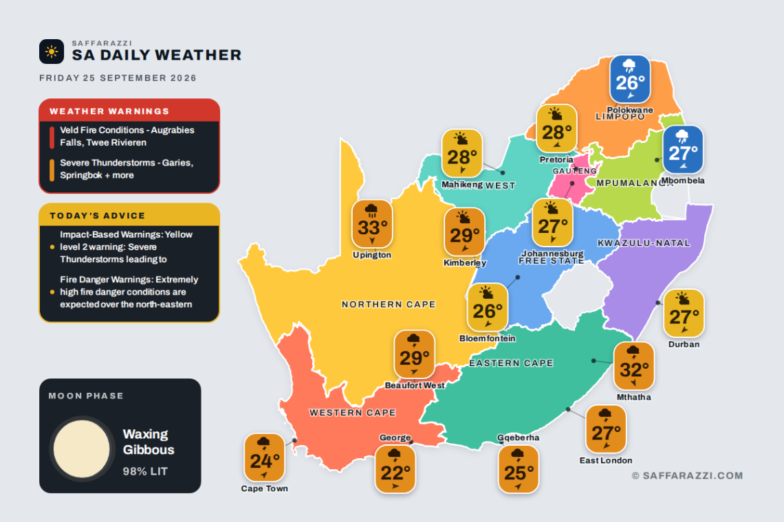
South Africa sees a mixed bag of weather today, Friday 25 September 2026, with showers and thundershowers soaking the Western Cape (Cape Town, 13-24C) and Eastern Cape (Gqeberha, 16-25C), while rain showers move through Limpopo (Polokwane, 13-26C) and Mpumalanga (Mbombela, 16-27C). The interior stays warmer and drier under high-level clouds in the Free State, North West and Northern Cape, where Kimberley climbs to a toasty 29C, and both Johannesburg and Durban enjoy partly cloudy conditions. Do take note of the active SAWS warnings today, with extreme veld fire conditions flagged in the drier regions and several minor severe thunderstorm alerts in place, so stay cautious whether you’re facing fire risk or stormy skies.
🎬 7-Day Weather Forecast Video
⚠️ Weather Warnings
Red level 10Veld Fire ConditionsAugrabies Falls, Twee Rivieren · from 08:00 on Friday 25 September, valid until 18:59 on 25 September▼
Areas: Augrabies Falls, Twee Rivieren.
Expected impacts
Conditions are such that the FDI index is above 75. Under these conditions fires may develop and spread rapidly resulting in damage to property and possible loss of human and/or animal life.
What to do ▼
All personnel and equipment should be removed from the field. Fire teams, labour and equipment are to be placed on full stand-by. At first sign of smoke, every possible measure should be taken in order to bring the fire under control in the shortest possible time. All available aircraft are to be called for without delay.
Yellow level 2Severe ThunderstormsGaries, Springbok, Prince Albert + 10 more · from 12:00 on Friday 25 September, valid until 23:59 on 26 September▼
Localised service disruption due to power surges/disruptions
Localised injuries (human and livestock)
Localised damage to property
Localised fire incidents (dwelling/veld fire).
What to do: If possible stay indoors away from metal objects. Do not seek shelter under trees or tall objects. Do not go fishing or play golf as both the golf clubs and fishing rods are good conductors of electricity. Members of the public are therefore advised to go indoors as soon as thunder roars.
Weather Advisories
1 itemImpact-Based WarningsYellow level 2 warning: Severe Thunderstorms leading to excessive lightning, large amounts of small hail, and gusty…▼
Yellow level 2 warning: Severe Thunderstorms leading to excessive lightning, large amounts of small hail, and gusty winds are expected over the western and southern parts of the Namakwa district municipality in the Northern Cape, as well as the Central Karoo and West Coast districts of the Western Cape.
1 itemFire Danger WarningsExtremely high fire danger conditions are expected over the north-eastern parts of the Northern Cape.▼
Extremely high fire danger conditions are expected over the north-eastern parts of the Northern Cape.
Moon Phase
🌔 Moon phase: Waxing Gibbous: more than half lit and still growing towards full – a building, almost-there phase.
The Moon is about 98% illuminated tonight, on day 13.3 of its 29.5-day cycle. It rises at 17:41 and sets at 05:40 (SAST). Next full moon: Saturday 26 September · next new moon: Sunday 11 October.
Rain60%WindSW 5 km/hFeels25°Humidity65-90%UVLowAir qualityPoor (64)Cloud75%Sun06:30 – 18:45TidesH 02:22 · L 08:23 · H 14:34 · L 20:46Sea15.7°C · 1.74 m waves · 11.7 s swell
SAWS outlook: Partly cloudy over the Little and Central Karoo during the morning, where there will be widespread showers and thundershowers by the afternoon, otherwise cloudy and warm with scattered showers and thundershowers. The wind along the coast will be light and variable along the west until the afternoon, otherwise moderate north-westerly, becoming fresh easterly to south-easterly from the afternoon. The expected UVB sunburn index: Very High.
The days ahead
Sat
20°/17°
Sun
19°/14°
Mon
22°/12°
Tue
24°/12°
Wed
26°/12°
Around the province
Stellenbosch23°/14°Showers and Thundershowers · N 5 km/h
Paarl26°/15°Showers and Thundershowers · NNW 5 km/h
George22°/16°Showers and Thundershowers · W 5 km/h
Rain0%WindNE 15 km/hFeels26°Humidity75-85%UVHighAir qualityModerate (54)Cloud75%Sun05:40 – 17:53TidesH 02:55 · L 08:58 · H 15:11 · L 21:21Sea22.2°C · 1.68 m waves · 10.4 s swell
SAWS outlook: Morning fog over the interior, otherwise partly cloudy and warm with isolated showers and thundershowers in the extreme south-west and north-east. The wind along the coast will be light to moderate northerly to north-easterly, becoming fresh in the afternoon. The expected UVB sunburn index: High.
Rain30%WindSW 15 km/hFeels23°Humidity80-95%UVLowAir qualityModerate (45)Cloud50%Sun06:01 – 18:16TidesH 02:47 · L 08:50 · H 15:02 · L 21:13Sea17.0°C · 2.2 m waves · 10.55 s swell
SAWS outlook: Western half: Morning fog in places in the south, otherwise fine and cool to warm becoming cloudy with scattered showers and thundershowers but isolated in places along the coast. The wind along the coast will be moderate north-easterly at first, otherwise moderate to fresh south-westerly. Eastern half: Cloudy with fog patches in places south of the escarpment, otherwise fine and warm to hot, becoming cloudy with isolated showers and thundershowers, except in the extreme east, but scattered in the north-west. The wind along the coast will be moderate north-easterly, becoming moderate to fresh south-westerly in the south by the afternoon, spreading to the rest of the coast by late evening.
The days ahead
Sat
20°/18°
Sun
18°/16°
Mon
16°/14°
Tue
17°/14°
Wed
19°/14°
Around the province
East London27°/19°Showers and Thundershowers · NE 10 km/h
Mthatha32°/15°Showers and Thundershowers · NNW 5 km/h
SAWS outlook: Cloudy in the east at fist, otherwise partly cloudy and warm with isolated afternoon showers and thundershowers expected over places in the east, as well as the south-western parts.
SAWS outlook: Morning fog patches along the escarpment, otherwise partly cloudy and cool to warm with isolated afternoon showers and thundershowers, except the extreme south-western parts.
Rain0%WindNE 10 km/hFeels29°Humidity20-40%UVModerateAir qualityModerate (58)Cloud50%Sun06:06 – 18:18TidesH 01:41 · L 07:37 · H 13:53 · L 20:04Sea14.1°C · 1.58 m waves · 11.7 s swell
SAWS outlook: Partly cloudy and warm to hot with isolated to scattered showers and thundershowers over the south-eastern and central parts, but widespread over the western parts and southern high-ground. The wind along the coast will be light and variable morning, otherwise fresh to strong easterly to north-easterly, but strong northerly along the northern coastline.
The days ahead
Sat
29°/19°
Sun
24°/14°
Mon
24°/13°
Tue
26°/13°
Wed
24°/13°
Around the province
Upington33°/17°Slight rain · N 15 km/h
Springbok26°/18°Showers and Thundershowers · ESE 5 km/h
De Aar28°/14°Showers and Thundershowers · NNW 10 km/h