

Monday looks like a decidedly wet and unsettled day across much of South Africa, with rain showers sweeping through the Western and Eastern Cape, moderate rain settling over Bloemfontein and Kimberley, and showers and thundershowers building across Gauteng and the North West. Durban and Polokwane hold onto cooler, cloudy skies while Mbombela sees some light drizzle, and with several weather advisories currently in place from the South African Weather Service, it’s worth keeping an eye on conditions and travelling with care. Temperatures stay mild for the most part, ranging from the chilly single digits in Bloemfontein up to a comfortable mid-20s in Johannesburg and Durban.
⚠️ Weather Warnings TL;DR
- Weather Advisory (Warning Advisory) – Grabouw, Garies and 10 more areas, valid until 23:59 on 14 September.
No new or upgraded warnings since this morning.
🎬 7 Day Weather Forecast Video
🗓️ Weather Warnings and Advice for the Days Ahead
Fire Danger Warnings
- Extremely high fire danger conditions are expected over the Western parts of the Waterberg District and the Blouberg municipality of Limpopo.
Advisories
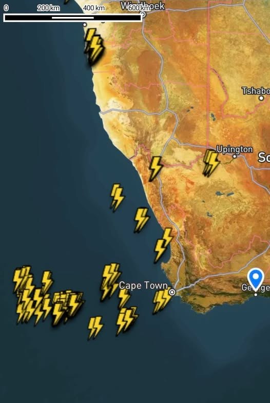
- A Cut-off low pressure system developing west of the country, is expected to affect the Western and Northern Cape provinces from Sunday into Monday (14/09/2026). The public and small stock farmers are advised that intermittent showers and thundershowers accompanied heavy downpours at times with possible large amounts of small hail and lightning, significant drop in temperatures over the high-lying areas, windy coastal and interior conditions as well as very rough seas (reaching 4.0 to 4.5 m south of Table Bay).
Source: South African Weather Service severe weather alerts.
Looking to Tomorrow
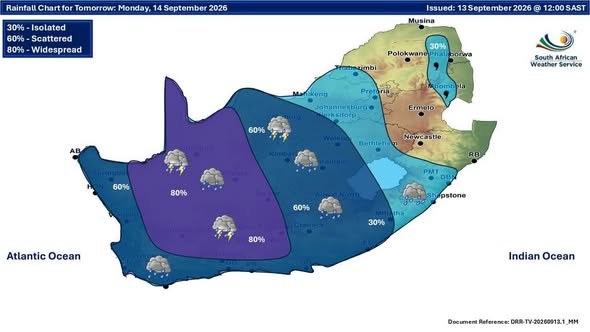
Bundle up and keep an umbrella handy across South Africa tomorrow, as showers, thundershowers, and rain sweep through most provinces under generally cool, cloudy skies. The Free State faces the widest swing from a chilly 8°C to 24°C, while the Western Cape stays coolest, topping out at just 18°C.
SAWS outlook for Monday 14 September, province by province
- Gauteng: Partly cloudy and cool to warm with isolated showers and thundershowers. The expected UVB sunburn index: High.
- Western Cape: Cloudy and cool to cold with scattered showers and thundershowers but widespread over the north-eastern parts. The wind along the coast will be moderate to fresh westerly to north-westerly. The expected UVB sunburn index: Moderate.
- KwaZulu-Natal: Morning fog patches over the interior, otherwise partly cloudy and cool to warm with isolated showers in the south. The wind along the coast will be moderate to fresh north-easterly. The expected UVB sunburn index: High.
- Eastern Cape: Western half: Windy in the north, otherwise cloudy and cool to warm with scattered showers and thundershowers, but widespread in the north-west. The wind along the coast will be moderate to fresh north-easterly becoming moderate to fresh south-westerly from late morning. Eastern half: Warm to hot with morning fog in places south of the escarpment, otherwise cloudy, windy and cool with scattered showers and thundershowers, but isolated in the north-east. The wind along the coast will be fresh to strong north-easterly, reaching gale force along the Wild Coast from the afternoon.
- Free State: Partly cloudy, windy and cool to warm with scattered showers and thundershowers but isolated in the north-east.
- Limpopo: Cloudy with morning drizzle along the escarpment, otherwise partly cloudy and cool to warm with isolated showers and thundershowers in the south-western Bushveld. It will be fine in paces over the north-western parts.
- Mpumalanga: Cloudy in the east with morning drizzle and fog patches in places over the eastern Highveld and the escarpment, otherwise partly cloudy and cool to warm with isolated showers and thundershowers in the extreme south-western parts.
- North West: Partly cloudy, windy and cool to warm with scattered showers and thundershowers but isolated in the east.
- Northern Cape: Cloudy, windy and cool to cold with scattered showers and thundershowers but widespread in the east and central. The wind along the coast will be moderate to fresh north-westerly.
Source: South African Weather Service regional forecast, issued 16:00.
From the Weather Community

Forecast data: South African Weather Service (weathersa.co.za).