Saffarazzi
  • HOME
  • Recipes
  • NEWS
    • Tech
    • Crypto
  • MOTORING
  • LIFESTYLE
    • ENTERTAINMENT
    • Viral
    • Horoscopes
  • LOTTO
    • Daily Lotto Results
    • Lotto
    • Powerball
    • UK Lottery Results
      • Thunderball
      • Lotto UK
      • EuroMillions
      • Set For Life
  • MORE
    • About Us
    • Contact Us
    • Write for us!
    • Newsletters and Notifications
    • SPORT
      • Soccer
      • Rugby
      • Cricket
      • Motorsport
  • Privacy
No Result
View All Result
  • HOME
  • Recipes
  • NEWS
    • Tech
    • Crypto
  • MOTORING
  • LIFESTYLE
    • ENTERTAINMENT
    • Viral
    • Horoscopes
  • LOTTO
    • Daily Lotto Results
    • Lotto
    • Powerball
    • UK Lottery Results
      • Thunderball
      • Lotto UK
      • EuroMillions
      • Set For Life
  • MORE
    • About Us
    • Contact Us
    • Write for us!
    • Newsletters and Notifications
    • SPORT
      • Soccer
      • Rugby
      • Cricket
      • Motorsport
No Result
View All Result
Saffarazzi
No Result
View All Result
Home News Weather

Weather Alert: Warning for Severe Thunderstorms Today (7-Day Forecast 21-27 Sept 2026)

Rain and thundershowers will affect most provinces on Monday, with clear skies in the Western Cape; severe thunderstorm and veld fire warnings are in effect.

Thandi Mokoena by Thandi Mokoena
2026-09-20 16:32
in Weather
South Africa weather forecast Monday 21 September 2026

South Africa weather Monday 21 September 2026. AI Generated.

FacebookTwitterWhatsappLinkedin

Monday looks wet and unsettled across much of the country, with showers and thundershowers spreading over Gauteng, KwaZulu-Natal, the Free State, Mpumalanga, North West and the Northern Cape, where several minor severe thunderstorm warnings are in place, so keep an umbrella handy and take care on the roads. Cape Town stands apart with clear skies and a warm high of 31C, while Gqeberha starts off misty and Polokwane stays cloudy, and Durban holds mild and muggy between 18 and 25C. Do bear in mind that extreme veld fire conditions remain a concern, so it is wise to stay cautious around dry, open areas even as the rain moves in elsewhere.

Your province's forecast for the week

GautengWeekendWestern CapeWeekendKwaZulu-NatalWeekendEastern CapeWeekendFree StateWeekendLimpopoWeekendMpumalangaWeekendNorth WestWeekendNorthern CapeWeekend

⚠️ New & Updated Weather Warnings

Red level 10Veld Fire ConditionsSpringbok · from 07:00 on Monday 21 September, valid until 20:59 on 21 September▼

Areas: Springbok.

ADVERTISEMENT

Expected impacts

  • Conditions are such that the FDI index is above 75. Under these conditions fires may develop and spread rapidly resulting in damage to property and possible loss of human and/or animal life.
What to do ▼

All personnel and equipment should be removed from the field. Fire teams, labour and equipment are to be placed on full stand-by. At first sign of smoke, every possible measure should be taken in order to bring the fire under control in the shortest possible time. All available aircraft are to be called for without delay.

Yellow level 2Severe ThunderstormsHlabisa, Hluhluwe, Dannhauser + 11 more · from 12:00 on Monday 21 September, valid until 23:59 on 21 September▼

Areas: Hlabisa, Hluhluwe, Dannhauser, Paulpietersburg, Utrecht, Dundee, Abaqulusi, Makatini, Riverview, Newcastle, Nongoma, Mbazwana, Richards Bay, uPhongolo.

  • Localised damage to infrastructure and settlements.
  • Localised flooding of susceptible roads and bridges.
  • Minor motor vehicle accidents due to slippery roads and poor visibility.
  • Difficult driving conditions on dirt and slippery roads.
  • Large amounts of small hail/ large hail over an open area.

What to do: Take caution or avoid traveling on bridges and roads in low lying areas as these may be susceptible to flooding and there may be sinkholes. Avoid outdoor activities as lightning, hail and flooding may result in injuries and death. If possible, stay indoors well clear of windows, shelter pets, and cover vehicles. Move livestock and cars to safe sheltered areas as there may be flying debris.

This morning’s other warnings remain in force – full details in today’s morning forecast.

🎬 7-Day Weather Forecast Video

🗓️ Weather Warnings and Advice for the Days Ahead

Fire Danger Warnings

  • Extremely high fire danger conditions are expected over the Nama-Khoi Municipality in Northern Cape.

Source: South African Weather Service severe weather alerts.

🌅 Tomorrow Across South Africa: Monday 21 September

Tomorrow brings a mixed bag across South Africa, with showers and thundershowers soaking Gauteng, KwaZulu-Natal, and the Free State, while the Western Cape enjoys clear skies and the Eastern Cape wakes to misty conditions. Expect the warmest temperatures in the Western Cape at 31°C, with Gauteng and the Free State dipping coolest to 12°C.

TownMin / MaxConditions
Pretoria13° / 25°CPartly cloudy with isolated showers and thundershowers. The expected UVB sunburn index: High
Johannesburg12° / 23°CPartly cloudy with isolated showers and thundershowers.
Vereeniging12° / 22°CPartly cloudy with isolated showers and thundershowers.
Mbombela16° / 26°CMorning fog and drizzle, otherwise cloudy with isolated showers.
Polokwane11° / 25°CCloudy in the morning, otherwise partly cloudy.
Mahikeng13° / 24°CPartly cloudy with isolated showers and thundershowers.
Vryburg13° / 25°CPartly cloudy with isolated showers and thundershowers.
Bloemfontein12° / 22°CPartly cloudy with isolated showers and thundershowers
Kimberley14° / 22°CPartly cloudy with isolated showers and thundershowers
Upington17° / 27°CPartly cloudy with isolated showers and thundershowers.
Cape Town16° / 31°CFine. The expected UVB sunburn index: High Wind: Light and variable.
George12° / 21°CPartly cloudy. Wind: Light and variable becoming moderate south-easterly from the afternoon.
Gqeberha14° / 20°CCloudy with morning and evening fog. Wind: Light and variable at first, otherwise light south-easterly, becoming north-easterly in the evening.
KuGompo City16° / 22°CCloudy with morning fog and isolated showers and rain from the afternoon. Wind: Light to moderate south-westerly, becoming north-easterly at night.
Durban18° / 25°CPartly cloudy with scattered afternoon showers and thundershowers. The expected UVB sunburn index: High Wind: Light and variable at first, otherwise light to moderate southerly to south -westerly.
Richards Bay18° / 28°CPartly cloudy with scattered afternoon showers and thundershowers. Wind: Light to moderate northerly to north-westerly, becoming southerly to south-westerly in the afternoon.
Pietermaritzburg13° / 24°CMorning fog, otherwise cloudy with scattered afternoon showers and thundershowers. AND OR

Source: South African Weather Service travellers forecast.

SAWS outlook for Monday 21 September, province by province

  • Gauteng: Partly cloudy and cool to warm with isolated showers and thundershowers. The expected UVB sunburn index: High.
  • Western Cape: Fine in the west, but cloudy along the south coast in the morning where it be cool, otherwise partly cloudy and warm to hot with isolated showers and thundershowers in the north -east. The wind along the coast will be fresh to strong southerly to south -easterly becoming easterly to northerly along the south coast in the evening. The expected UVB sunburn index: High.
  • KwaZulu-Natal: Morning fog over the interior, otherwise partly cloudy and cool to warm with scattered afternoon showers and thundershowers. The wind along the coast will be light to moderate northerly to north-easterly, becoming light to moderate south-westerly in the south from mid-morning, spreading northwards to Cape St. Lucia. The expected UVB sunburn index: High AND OR.
  • Eastern Cape: Western half: Partly cloudy and cool with morning fog in the south and isolated showers and thundershowers but scattered in the north-east. The wind along the coast will be light to moderate south-easterly, becoming north-easterly from the evening. Eastern half: Morning fog is expected in places along the coast and adjacent interior; otherwise, it will be partly cloudy and cool, with isolated showers and thundershowers, scattered over the interior. The wind along the coast will be light to moderate south-westerly, becoming north-easterly at night.
  • Free State: Cloudy at first, otherwise partly cloudy and cool to warm with isolated showers and thundershowers.
  • Limpopo: Cloudy with morning chance of drizzle and fog in the east, otherwise cloudy partly and warm.
  • Mpumalanga: Morning chance of drizzle and fog along the escarpment, otherwise partly cloudy and cool with isolated rain and showers, except in the Lowveld where it will be cloudy and warm.
  • Northern Cape: Cloudy in the south at first, otherwise partly cloudy and cool to warm with isolated showers and thundershowers. The wind along the coast will be moderate southerly to south-easterly.

Source: South African Weather Service regional forecast, issued 16:00.

From the Weather Community
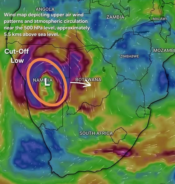
Weather post shared in the Severe Weather and Information Centre SA group

🌍 A fascinating look at Southern Africa’s atmosphere at 07:15 today These two maps provide an excellent snapshot of how weather systems at different levels of the atmosphere are interacting across Southern Africa this morning. 🌀 500 hPa — the upper atmosphere At approximately 5.5 km above sea level (500 hPa), a well-defined Cut-Off Low (COL) is evident over Namibia. The system is detached from the main westerly flow and exhibits cyclonic (clockwise) circulation, as expected in the Southern Hemisphere. The COL is associated with colder air aloft, increased atmospheric instability and…

Shared today in the Severe Weather and Information Centre SA group · See the post in the group

Weather post shared in the Severe Weather and Information Centre SA group

🌤️ Good morning and happy Sunday from a sunny but cool George in the Western Cape! ☕ ⚠️🟣 HEADS-UP | Advanced Forecast — Subject to Change 1️⃣ Severe thunderstorms may develop over parts of the southern Northern Cape, northern and north-eastern Western Cape, interior of the Eastern Cape and KwaZulu-Natal today. Where storms develop, they could produce heavy downpours, large hail, excessive lightning and damaging wind gusts. 2️⃣ Atmospheric conditions are expected to become increasingly favourable for the development of showers and thundershowers across large parts of South Africa during…

Shared today in the Severe Weather and Information Centre SA group · See the post in the group

Forecast data: South African Weather Service (weathersa.co.za) and various 3rd party providers and AI Tools.

Tags: SA WeatherWeather ForecastWeather Warnings
  • About
  • Terms and Conditions
  • Corrections & Complaints
  • Contact Us
South Africa News, Entertainment, Lifestyle, Sport.

© saffarazzi.com. All Rights Reserved. Privacy Policy.
hello @ saffarazzi.com

No Result
View All Result
  • HOME
  • RECIPES
  • NEWS
  • ENTERTAINMENT
  • LIFESTYLE
  • MOTORING
  • LOTTO RESULTS
    • Daily Lotto Results
    • Lotto
    • Powerball
    • UK Lottery
      • Thunderball
      • Lotto UK
      • EuroMillions
      • Set For Life
  • About Us
  • Write for us!
  • Contact Us
  • Privacy & Terms
  • Corrections & Complaints

© saffarazzi.com. All Rights Reserved. Privacy Policy.
hello @ saffarazzi.com

No Result
View All Result
  • HOME
  • RECIPES
  • NEWS
  • ENTERTAINMENT
  • LIFESTYLE
  • MOTORING
  • LOTTO RESULTS
    • Daily Lotto Results
    • Lotto
    • Powerball
    • UK Lottery
      • Thunderball
      • Lotto UK
      • EuroMillions
      • Set For Life
  • About Us
  • Write for us!
  • Contact Us
  • Privacy & Terms
  • Corrections & Complaints

© saffarazzi.com. All Rights Reserved. Privacy Policy.
hello @ saffarazzi.com