

Thursday looks unsettled across much of the country, with showers and thundershowers spreading over Gauteng, the Free State, Mpumalanga, North West and the Northern Cape, while Durban and Gqeberha can expect moderate rain and rain showers along the coast. The Western Cape and Limpopo get off a little lighter with partly cloudy skies, though it stays cool in Cape Town at 12 to 19 degrees and warmer up in Polokwane reaching 28. Do keep an eye on the SAWS warnings still in play for the rest of today, including a minor alert for severe thunderstorms and several for damaging winds, so take care if you’re out and about.
Your province's forecast for the week
⚠️ Weather Warnings TL;DR
- Severe Thunderstorms (Warning Level 2) – Rustenburg, valid until 23:59 on 18 September.
- Damaging Winds (Warning Level 2) – Grabouw, Garies and 9 more areas, valid until 23:59 on 18 September.
No new or upgraded warnings since this morning.
🎬 7-Day Weather Forecast Video
🗓️ Weather Warnings and Advice for the Days Ahead
Fire Danger Warnings
- Extremely high fire danger is expected over the western Bushveld of Limpopo.
Advisories
- Very cold, wet and windy conditions are expected over the south-western parts of KwaZulu-Natal, southern parts of the Northern Cape as well as Cape Winelands, Central Karoo and Little Karoo districts of the Western Cape, the Eastern Cape, and the eastern and southern parts of the Free State until Friday. Light snowfall is possible over the high lying areas of the Western Cape.
Source: South African Weather Service severe weather alerts.
🌅 Tomorrow Across South Africa: Thursday 17 September
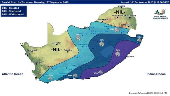
Tomorrow brings a wet spell across much of South Africa, with rain and thundershowers expected in Gauteng, the Free State, KwaZulu-Natal, and the Eastern Cape, while the Western Cape stays a little brighter with partly cloudy skies. Expect the widest temperature swing in the Free State, ranging from a chilly 8°C to a mild 27°C.
| Town | Min / Max | Conditions |
|---|---|---|
| Pretoria | 12° / 29°C | Partly cloudy with isolated showers and thundershowers. UVB Sunburn Index: High |
| Johannesburg | 9° / 26°C | Partly cloudy with isolated showers and thundershowers. |
| Vereeniging | 10° / 26°C | Partly cloudy with isolated showers and thundershowers. |
| Mbombela | 12° / 27°C | Cloudy. |
| Polokwane | 13° / 28°C | Partly cloudy. |
| Mahikeng | 13° / 30°C | Partly cloudy and windy with isolated thundershowers. |
| Vryburg | 11° / 29°C | Partly cloudy with isolated thundershowers. |
| Bloemfontein | 8° / 22°C | Partly cloudy with scattered showers and thundershowers. |
| Kimberley | 6° / 22°C | Partly cloudy with isolated thundershowers. |
| Upington | 10° / 23°C | Partly cloudy. |
| Cape Town | 12° / 19°C | Partly cloudy. Wind: Moderate south-easterly, becoming strong in the afternoon. UVB Sunburn Index: Low |
| George | 11° / 16°C | Cloudy with scattered showers and rain. Wind: Moderate to fresh south-easterly. |
| Gqeberha | 12° / 15°C | Cloudy with widespread showers and rain. Wind: Moderate to fresh south-easterly. |
| KuGompo City | 13° / 15°C | Cloudy with widespread showers and rain. Wind: Light and variable, becoming moderate to fresh south- easterly in the afternoon. |
| Durban | 16° / 18°C | Cloudy with widespread showers and rain. Wind: Moderate to fresh south-westerly, becoming fresh southerly to south-easterly from late afternoon. UVB Sunburn Index: Low |
| Richards Bay | 17° / 20°C | Cloudy with widespread showers and rain. Wind: Moderate to fresh south-westerly. |
| Pietermaritzburg | 11° / 14°C | Cloudy with widespread showers and rain. Service) |
Source: South African Weather Service travellers forecast.
SAWS outlook for Thursday 17 September, province by province
- Gauteng: Partly cloudy and warm with isolated showers and thundershowers. The expected UVB sunburn index: High.
- Western Cape: Partly cloudy the west and south-west, otherwise cloudy and cool to cold with isolated showers and rain over the central and eastern parts but scattered along the eastern parts of the south-coast. It will be windy in places from afternoon. The wind along the coast will be moderate to fresh south-easterly, but strong in the south-west. The expected UVB sunburn index: Low.
- KwaZulu-Natal: Morning fog patches over the western parts, otherwise cloudy and cold to cool but very cold in the south-west. Scattered showers and thundershowers are expected over the extreme northern parts, otherwise widespread. The wind along the coast will be moderate to fresh south-westerly, becoming moderate to fresh southerly to south-easterly in the south in the afternoon. The expected UVB sunburn index: Low.
- Eastern Cape: Western half: Cloudy and cold to very cold with widespread showers and rain but scattered in the north and the extreme west. The wind along the coast will be moderate to fresh south-easterly. Eastern half: Cloudy and cold to very cold with widespread showers and rain, but scattered in the north-west. The wind along the coast will be moderate to fresh south-easterly.
- Free State: Cloudy, windy and cool to warm with scattered showers and thundershowers but isolated in the west where it will be partly cloudy.
- Limpopo: Partly cloudy and warm.
- Mpumalanga: Cloudy in the east, otherwise partly cloudy and cool to warm with isolated to scattered showers and thundershowers over the Highveld.
- Northern Cape: Partly cloudy and cool to warm but cloudy, windy and cold in the south Isolated showers and thundershowers are expected in the east, and south-east. The wind along the coast will be fresh to strong south-easterly.
Source: South African Weather Service regional forecast, issued 16:00.
From the Weather Community

Forecast data: South African Weather Service (weathersa.co.za).