Skip to content
Home » News » Weather » Today’s Weather Forecast (Tuesday, 10 November 2026)
Weather

Today’s Weather Forecast (Tuesday, 10 November 2026)

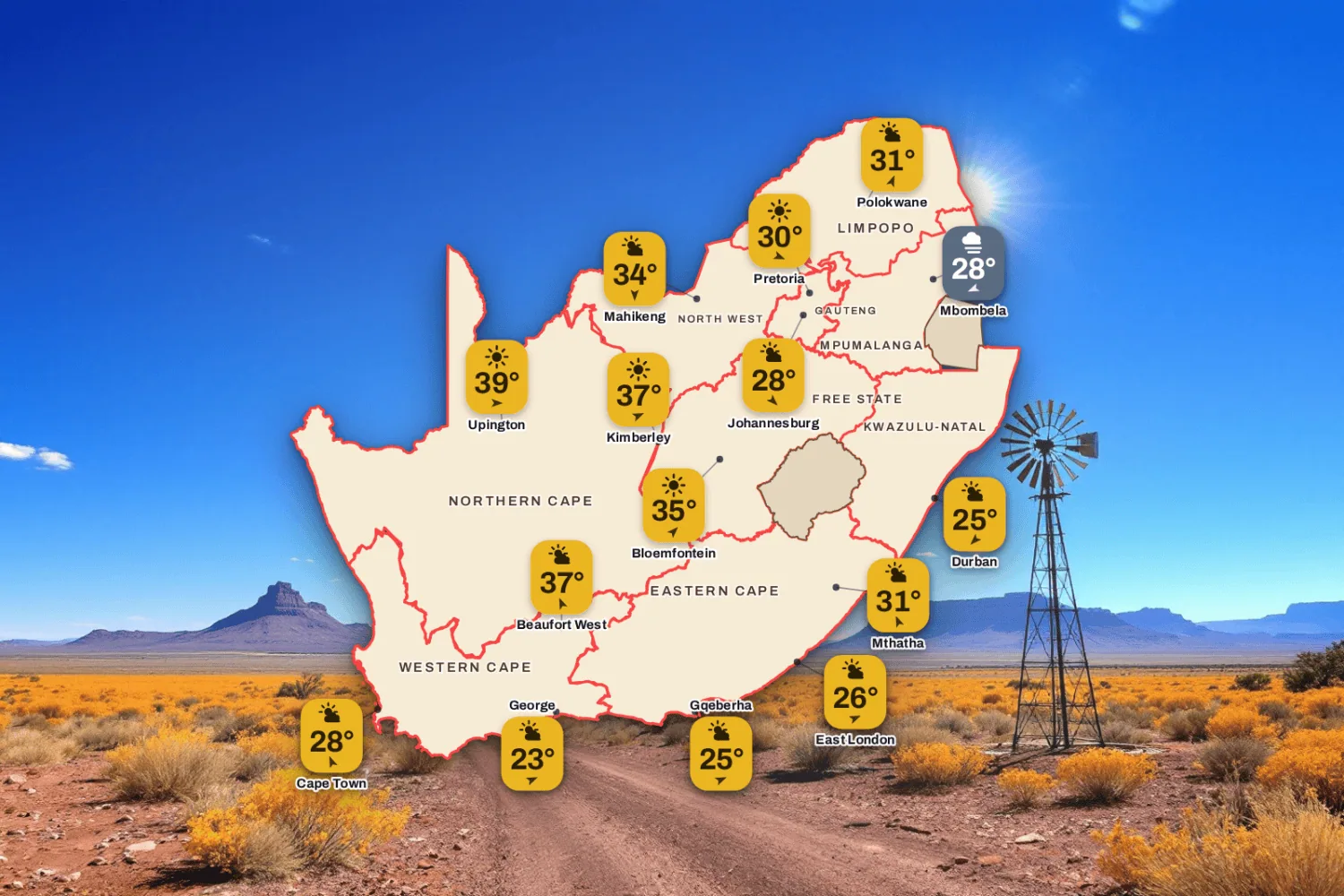
The weather for 10 November 2026: Hot clear interior, patchy cloud and mist. Hottest in Northern Cape at 37°C, coldest in Free State at 10°C.

South Africa weather map for Tuesday 10 November 2026 with temperatures for Cape Town, Johannesburg, Durban and more.
Today's highs and lows across the country, with SAWS warnings and the moon phase. Visuals by PubgentIQ AI

Updated Tuesday 10 November 2026, 05:31 SAST

Hot clear interior, patchy cloud and mist. Today’s weather for 34 towns across the nine provinces: the sky, the high and the low, the chance of rain and the wind, town by town.

Advertisement

Weather Warnings Today

Red level 10
Veld Fire Conditions
Postmasburg, De Aar, Schweizer-Reneke + 28 more · from 08:00 on Tuesday 10 November, valid until 19:59 on 10 November
Areas
  • Postmasburg
  • De Aar
  • Schweizer-Reneke
  • Griquastad
  • Hoopstad
  • Groblershoop
  • Prieska
  • Kathu
  • Augrabies Falls
  • Warrenton
  • Bloemhof
  • Hopetown
  • Bloemfontein Airport
  • Fauresmith
  • Kimberley
  • Victoria West
  • Brandfort
  • Welkom
  • Daniëlskuil
  • Upington
  • Petrusville
  • Noupoort
  • Dealesville
  • Kuruman
  • Barkly West
  • Koffiefontein
  • Twee Rivieren
  • Klerksdorp
  • Jan Kempdorp
  • Kroonstad
  • VanWyksvlei
Expected impacts
  • Conditions are such that the FDI index is above 75. Under these conditions fires may develop and spread rapidly resulting in damage to property and possible loss of human and/or animal life.
What to do ▼
All personnel and equipment should be removed from the field. Fire teams, labour and equipment are to be placed on full stand-by. At first sign of smoke, every possible measure should be taken in order to bring the fire under control in the shortest possible time. All available aircraft are to be called for without delay.

Today’s Weather for Major Cities and Towns

Gauteng

4 towns today
Johannesburg
Partly cloudy
28°/13°
0% rain
NW 5 km/h
Pretoria
Mostly clear
30°/11°
0% rain
WNW 5 km/h
Soweto
Partly cloudy
27°/10°
0% rain
NW 5 km/h
Vereeniging
Partly cloudy
28°/10°
0% rain
SW 10 km/h

Western Cape

4 towns today
Cape Town
High level clouds
28°/18°
0% rain
SSE 10 km/h
Stellenbosch
High level clouds
31°/13°
0% rain
SSW 10 km/h
Paarl
High level clouds
34°/15°
0% rain
WSW 10 km/h
George
High level clouds
23°/15°
0% rain
WSW 5 km/h

KwaZulu-Natal

4 towns today
Durban
Partly cloudy
25°/16°
0% rain
NE 15 km/h
Pietermaritzburg
Partly cloudy
29°/10°
0% rain
ESE 5 km/h
Richards Bay
Mostly clear
29°/14°
0% rain
N 5 km/h
Newcastle
Mostly clear
32°/10°
0% rain
SE 5 km/h

Eastern Cape

4 towns today
Gqeberha
High level clouds
25°/16°
0% rain
WSW 15 km/h
East London
High level clouds
26°/15°
0% rain
WSW 10 km/h
Mthatha
Partly cloudy
31°/12°
0% rain
SSE 10 km/h
Queenstown
High level clouds
32°/9°
0% rain
SSW 5 km/h
Advertisement

Free State

3 towns today
Bloemfontein
Mostly clear
35°/10°
0% rain
SW 10 km/h
Bethlehem
Partly cloudy
31°/7°
0% rain
WSW 10 km/h
Kroonstad
Partly cloudy
35°/12°
0% rain
SW 10 km/h

Limpopo

4 towns today
Polokwane
Partly cloudy
31°/13°
0% rain
SSW 10 km/h
Tzaneen
Partly cloudy
30°/19°
0% rain
SW 0.1 km/h
Thohoyandou
Partly cloudy
31°/16°
0% rain
ESE 5 km/h
Musina
Partly cloudy
30°/18°
0% rain
ENE 5 km/h

Mpumalanga

3 towns today
Mbombela
Mist
28°/14°
0% rain
ENE 5 km/h
eMalahleni
Partly cloudy
28°/10°
0% rain
WNW 5 km/h
Ermelo
Fog
26°/8°
0% rain
W 5 km/h

North West

4 towns today
Mahikeng
Partly cloudy
34°/17°
0% rain
N 10 km/h
Rustenburg
Partly cloudy
34°/16°
0% rain
NW 5 km/h
Potchefstroom
Partly cloudy
33°/13°
0% rain
NNW 10 km/h
Klerksdorp
Partly cloudy
35°/14°
0% rain
NW 10 km/h

Northern Cape

4 towns today
Kimberley
Mostly clear
37°/13°
0% rain
WSW 10 km/h
Upington
Mostly clear
39°/18°
0% rain
W 10 km/h
Springbok
High level clouds
36°/20°
0% rain
WSW 10 km/h
De Aar
Mostly clear
35°/12°
0% rain
W 10 km/h

How SAWS weather warning levels work

The South African Weather Service issues impact-based warnings. They say what the weather could do to people, roads and homes, not only how strong it will be. Each warning has a colour and a level from 1 to 10.

  • Yellow (Levels 1 to 4): minor to moderate impact. Local disruption such as flooded streets, travel delays or damage to informal homes. Stay alert.
  • Orange (Levels 5 to 8): significant impact. Major travel problems, power cuts, flooding in low-lying areas and damage to property are likely. Prepare and take action.
  • Red (Levels 9 and 10): severe impact. Widespread flooding, washed-away roads, damaged buildings and danger to life. Take emergency precautions at once.

The number also reflects how likely the impact is, so two warnings of the same colour can differ in how likely they are to happen. Always follow SAWS and your local disaster management.

Forecast data: South African Weather Service (weathersa.co.za) and various 3rd party providers and AI Tools.

Enjoyed this story? We need your help.

Add Saffarazzi as a preferred source. You’ll see more of our stories on Google, and you’ll help us grow.

Advertisement