

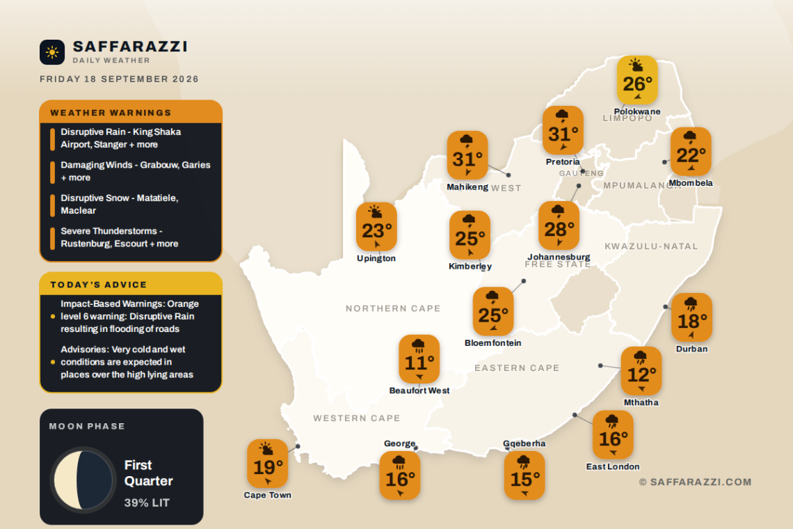

Wet and unsettled weather dominates much of South Africa today, with showers and thundershowers sweeping across Gauteng, the Free State, Mpumalanga, North West and the Northern Cape, while rain showers dampen Durban and Gqeberha. Cape Town and Polokwane escape the worst, offering partly cloudy skies and milder conditions, though temperatures elsewhere range widely from a chilly 9°C in Bloemfontein to a warm 31°C in Mahikeng. Six moderate Disruptive Rain warnings are currently in place from the SAWS, so motorists and residents in affected areas are urged to take care as the rain sets in.
🎬 7-Day Weather Forecast Video
⚠️ Weather Warnings
Disruptive Rain (Warning Level 6), valid until 23:59 on 18 September.
Areas: King Shaka Airport, Stanger, Mandini, Maphumulo, Camperdown, Ndwedwe, Margate, Pennington, St Faith’s (Cathula).
- Flooding of roads, bridges and settlements (formal and informal)
- Danger to life (fast flowing streams/deep waters)
- Major disruption of traffic flow due to major roads being flooded
- Disruption to essential services (Water, electricity, communication, etc).
- Damage to mud-based houses.
If possible avoid crossing rivers and swollen streams where water is above your ankles. If trapped in a vehicle during a flood, abandon it and climb to higher ground. In buildings, move valuables to a safe place above the expected flood level. Switch off electricity at the supply point to the building. In rural areas protect/relocate animals to a safe place on higher ground. Take caution when traveling or avoid traveling as roads may be flooded, with potholes being filled with water and there may be sinkholes.
Disruptive Rain (Warning Level 4), valid until 23:59 on 18 September.
Areas: Underberg, Kokstad, Impendle, Donnybrook, Giants Castle, Mooi River, Melmoth, Nkandla, Richmond, Pietermaritzburg, Ixopo, Ulundi and 10 more areas.
- Major disruption of traffic flow due to major roads being flooded or closed.
- Damage to property, infrastructure, loss of livelihood and livestock.
- Danger to life (fast flowing streams / deep water).
- Displacement of affected communities.
- Some communities temporarily not accessible/cut-off.
Take caution or avoid traveling on bridges and roads in low lying areas as these may be susceptible to flooding and there may be sinkholes.
Damaging Winds (Warning Level 2), valid until 23:59 on 18 September.
Areas: Grabouw, Garies, Springbok, Worcester, Prince Albert, Paarl, Redelinghuys, Swellendam, Ceres, Hermanus, Robertson, Cape Agulhas and 12 more areas.
- Localised damage to settlements (formal and informal) and temporary structures.
- Some transport routes and travel services will be affected by wind while some journeys may require longer travel times.
- Localised problems for high-sided vehicles on prone routes due to cross winds on exposed high-level roads
Stay indoors where possible away from the windows that open towards the severe winds. Be aware of the following: – sudden cross winds if traveling especially between buildings, fallen trees or power lines and flying debris.Parked aircraft should be pointed into the direction of the wind and secured. Ensure that all temporary structures are well anchored.
Damaging Winds (Warning Level 2), valid until 23:59 on 18 September.
Areas: Alexanderbaai.
- Localised damage to settlements (formal and informal) and temporary structures.
- Some transport routes and travel services will be affected by wind while some journeys may require longer travel times.
- Localised problems for high-sided vehicles on prone routes due to cross winds on exposed roads (such as parts of the N1)
- Isolated incidents of uprooted trees
Stay indoors where possible away from the windows that open towards the severe winds. Be aware of the following: – sudden cross winds if traveling especially between buildings, fallen trees or power lines and flying debris.Parked aircraft should be pointed into the direction of the wind and secured. Ensure that all temporary structures are well anchored.
Disruptive Rain (Warning Level 2), valid until 23:59 on 18 September.
Areas: Matatiele, Mount Ayliff, Libode, Tsolo, Lusikisiki, Peddie, Somerset East, Port St Johns, Mthatha, Stutterheim, East london, Komga and 5 more areas.
- Localised flooding of roads, bridges, settlements (formal/informal) and low-lying bridges.
- Difficult disruptions to power supply and communications
- Localised traffic disruption, major roads maybe affected but can be used
- Difficult driving conditions on dirt roads
DO NOT cross flooded rivers/areas Road users are advised to be cautious on the roads Increase travel times. Listen for regular weather updates via radio and/or social media. Monitor the weather conditions and if need be, identify areas to safely store valuable items away from flood water.
Weather Advisories
Impact-Based Warnings
- Orange level 6 warning: Disruptive Rain resulting in flooding of roads and settlements (formal and informal), danger to life (fast flowing streams/ deep water), displacement of affected communities, loss of livelihood and livestock is expected along the coast and adjacent interior of KwaZulu-Natal up to Richards Bay.
- Orange level 5 warning: Disruptive Rain resulting in flooding of settlements, roads and bridges, and disruption to essential services, is expected over Port St Johns, Ingquza Hill, Winnie Madikizela-Mandela and Ntabankulu local municipalities in of the Eastern Cape.
- Yellow level 4 warning: Disruptive Rain resulting in flooding of roads and settlements (formal and informal), danger to life (fast flowing streams/ deep water), displacement of affected communities, loss of livelihood and livestock is expected over the eastern and southern parts of KwaZulu-Natal.
- Yellow level 4 warning: Severe Thunderstorms accompanied by heavy downpours, with a possibility of damaging winds, excessive lightning and hail, leading to injuries and danger to life, as well as localised flooding of susceptible settlements and infrastructure, are expected over the extreme east-central parts of the Northern Cape.
- Yellow level 2 warning: Severe Thunderstorms accompanied by heavy downpours, with a possibility of damaging winds, excessive lightning and hail, leading to injuries and danger to life, as well as localised flooding of susceptible settlements and infrastructure, are expected over the eastern parts of Northern Cape (except for the extreme east-central), western parts of Free State, and the north-western parts of KwaZulu-Natal.
- Yellow level 2 warning: Disruptive rain resulting in localised flooding of settlements, roads and low-lying bridges, localised disruptions to power supply and communications is expected over coastal areas and adjacent interior between KuGompo City and Port St Johns, including the extreme north-eastern interior of the Eastern Cape.
- Yellow level 2 warning: Damaging Winds resulting in localised damage to settlements, localised interruption to power and communications and difficult driving conditions is expected over the southern and western parts of the Northern Cape and the northern parts of the Western Cape as well as the eastern parts of the North West and Free State. .
- Yellow level 2 warning: Disruptive Snow resulting in isolated loss of vulnerable livestock and difficult driving conditions, is expected over Matatiele and Elundini local municipalities of the Eastern Cape.
Advisories
- Very cold and wet conditions are expected in places over the high lying areas of the Eastern Cape and the south-western parts of KwaZulu-Natal.
Moon Phase
🌓 Moon phase: First Quarter: half the Moon is lit and growing – the halfway climb to full, associated with decision-making and momentum.
The Moon is about 39% illuminated tonight, on day 6.3 of its 29.5-day cycle. It rises at 10:03 and sets at 01:14 (SAST). Next full moon: Saturday 26 September · next new moon: Sunday 11 October.
Weather by Province
From the Weather Community
Forecast data: South African Weather Service (weathersa.co.za) and various 3rd party providers and AI Tools.