Today’s Weather: Warning for Severe Thunderstorms – 21 September
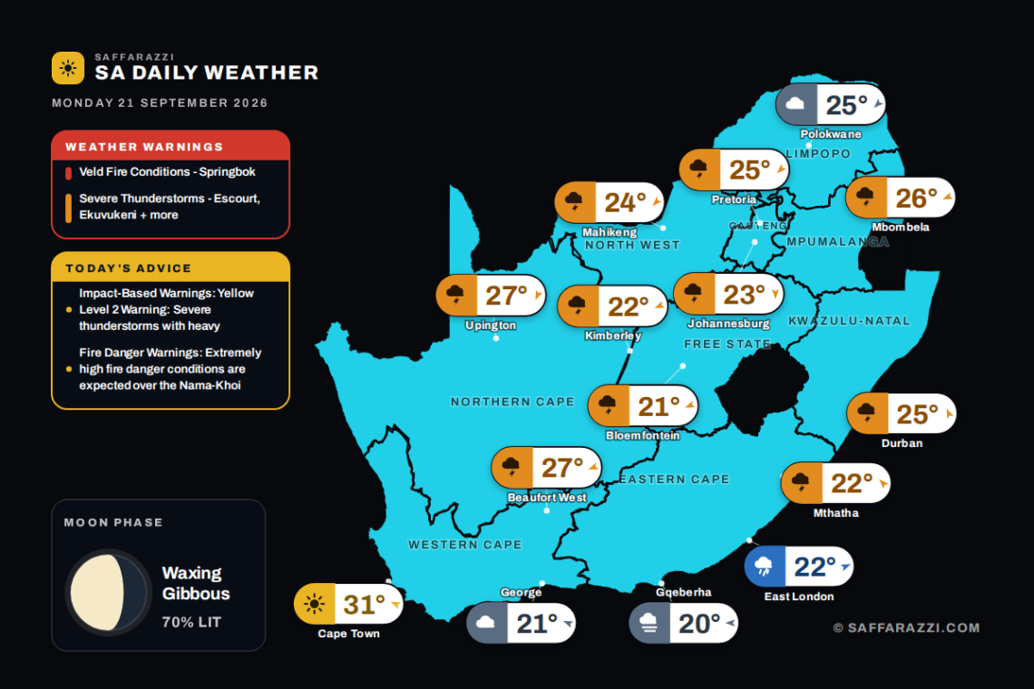
Widespread showers and thundershowers hit most provinces today with the Western Cape clear, while SAWS warns of severe thunderstorms and veld fire conditions.
Wet and stormy weather dominates much of South Africa today, with showers and thundershowers expected across Gauteng, KwaZulu-Natal, the Free State, Mpumalanga, North West and the Northern Cape, while Johannesburg stays cool between 12 and 23 degrees. Cape Town is the standout exception with clear skies and a warm high of 31 degrees, though Gqeberha wakes up to misty conditions and Polokwane remains cloudy. Keep an eye on the SAWS warnings today, with extreme veld fire conditions flagged alongside several minor severe thunderstorm alerts, so stay cautious whether you’re facing dry heat or the risk of storms.
🎬 7-Day Weather Forecast Video
⚠️ Weather Warnings
Red level 10Veld Fire ConditionsSpringbok · from 07:00 on Monday 21 September, valid until 20:59 on 21 September▼
Areas: Springbok.
ADVERTISEMENT
Expected impacts
Conditions are such that the FDI index is above 75. Under these conditions fires may develop and spread rapidly resulting in damage to property and possible loss of human and/or animal life.
What to do ▼
All personnel and equipment should be removed from the field. Fire teams, labour and equipment are to be placed on full stand-by. At first sign of smoke, every possible measure should be taken in order to bring the fire under control in the shortest possible time. All available aircraft are to be called for without delay.
Yellow level 2Severe ThunderstormsEscourt, Ekuvukeni, Ladysmith + 45 more · from 12:00 on Monday 21 September, valid until 23:59 on 21 September▼
Areas: Escourt, Ekuvukeni, Ladysmith, Hlabisa, Hluhluwe, Dannhauser, Underberg, Paulpietersburg, Utrecht, Dundee, King Shaka Airport, Kokstad, Impendle, Donnybrook, Abaqulusi, Goodhom, Makatini, Stanger, Mandini, Maphumulo, Camperdown, Giants Castle, Mooi River, Pomeroy, Melmoth, Riverview, Ndwedwe, Newcastle, Nkandla, Nongoma, Nqutu, Royal National Park, Margate, Richmond, Pietermaritzburg, Ixopo, Ulundi, Pennington, Mbazwana, Richards Bay and 8 more.
Localised damage to infrastructure and settlements.
Localised flooding of susceptible roads and bridges.
Minor motor vehicle accidents due to slippery roads and poor visibility.
Difficult driving conditions on dirt and slippery roads.
Large amounts of small hail/ large hail over an open area.
What to do: Take caution or avoid traveling on bridges and roads in low lying areas as these may be susceptible to flooding and there may be sinkholes. Avoid outdoor activities as lightning, hail and flooding may result in injuries and death. If possible, stay indoors well clear of windows, shelter pets, and cover vehicles. Move livestock and cars to safe sheltered areas as there may be flying debris.
Weather Advisories
1 itemImpact-Based WarningsYellow Level 2 Warning: Severe thunderstorms with heavy downpours, hail and excessive lightning resulting in localised…▼
Yellow Level 2 Warning: Severe thunderstorms with heavy downpours, hail and excessive lightning resulting in localised flooding, damage to infrastructure and settlements are expected across KwaZulu-Natal.
1 itemFire Danger WarningsExtremely high fire danger conditions are expected over the Nama-Khoi Municipality in Northern Cape.▼
Extremely high fire danger conditions are expected over the Nama-Khoi Municipality in Northern Cape.
Moon Phase
🌔 Moon phase: Waxing Gibbous: more than half lit and still growing towards full – a building, almost-there phase.
The Moon is about 70% illuminated tonight, on day 9.3 of its 29.5-day cycle. It rises at 13:37 and sets at 03:36 (SAST). Next full moon: Saturday 26 September · next new moon: Sunday 11 October.
Rain0%WindESE 5 km/hFeels33°Humidity50-85%UVLowAir qualityPoor (66)Cloud5%Sun06:36 – 18:42TidesL 05:30 · H 12:00 · L 18:10Sea14.2°C · 2.04 m waves · 9.55 s swell
SAWS outlook: Fine in the west, but cloudy along the south coast in the morning where it be cool, otherwise partly cloudy and warm to hot with isolated showers and thundershowers in the north-east. The wind along the coast will be fresh to strong southerly to south-easterly becoming easterly to northerly along the south coast in the evening. The expected UVB sunburn index: High.
Rain60%WindSSE 10 km/hFeels25°Humidity75-85%UVLowAir qualityExtremely poor (133)Cloud75%Sun05:45 – 17:51TidesL 06:30 · H 13:00 · L 19:06Sea21.9°C · 1.44 m waves · 9.8 s swell
SAWS outlook: Morning fog over the interior, otherwise cloudy and cool to warm with scattered afternoon showers and thundershowers. The wind along the coast will be light to moderate northerly to north-easterly, becoming light to moderate south-westerly in the south from mid-morning, spreading northwards to Cape St. Lucia. The expected UVB sunburn index: High AND OR.
The days ahead
Tue
23°/20°
Wed
26°/20°
Thu
23°/21°
Fri
23°/20°
Sat
25°/20°
Sun
24°/20°
Around the province
Pietermaritzburg25°/13°Showers and Thundershowers · ESE 5 km/h
Richards Bay30°/17°Showers and Thundershowers · N 5 km/h
Newcastle24°/11°Showers and Thundershowers · ESE 5 km/h
Rain0%WindE 15 km/hFeels18°Humidity85-95%UVLowAir qualityModerate (53)Cloud75%Sun06:07 – 18:13TidesL 06:10 · H 12:47 · L 18:47Sea17.4°C · 2.06 m waves · 10.65 s swell
SAWS outlook: Western half: Cloudy and cool with morning fog in the south and isolated showers and thundershowers, but scattered in the north-east. The wind along the coast will be light to moderate south-easterly, becoming north-easterly from the evening. Eastern half: Morning fog in places along the coast and adjacent interior, otherwise cloudy and cool with isolated showers and thundershowers, but scattered over the interior. The wind along the coast will be light to moderate south-westerly, becoming north-easterly at night.
The days ahead
Tue
25°/17°
Wed
22°/16°
Thu
19°/17°
Fri
22°/17°
Sat
20°/16°
Around the province
East London22°/16°Rain showers · WSW 5 km/h
Mthatha22°/14°Showers and Thundershowers · SE 5 km/h
SAWS outlook: Morning chance of drizzle and fog along the escarpment, otherwise partly cloudy and cool with isolated rain and showers, except in the Lowveld where it will be cloudy and warm.
The days ahead
Tue
27°/15°
Wed
29°/14°
Thu
28°/14°
Fri
28°/15°
Sat
31°/15°
Sun
32°/16°
Around the province
eMalahleni23°/10°Showers and Thundershowers · N 5 km/h
Ermelo22°/9°Showers and Thundershowers · ENE 5 km/h
Rain30%WindENE 5 km/hFeels23°Humidity35-65%UVLowAir qualityPoor (64)Cloud75%Sun06:10 – 18:16TidesL 05:30 · H 12:04 · L 18:10Sea14.0°C · 1.86 m waves · 10.3 s swell
SAWS outlook: Cloudy in the south at first, otherwise partly cloudy and cool to warm with isolated showers and thundershowers, except in the west. The wind along the coast will be moderate southerly to south-easterly.
The days ahead
Tue
27°/15°
Wed
27°/17°
Thu
29°/17°
Fri
29°/17°
Sat
26°/17°
Around the province
Upington27°/15°Showers and Thundershowers · NNE 10 km/h
Springbok29°/18°Partly cloudy · NE 20 km/h
De Aar23°/11°Showers and Thundershowers · ENE 5 km/h