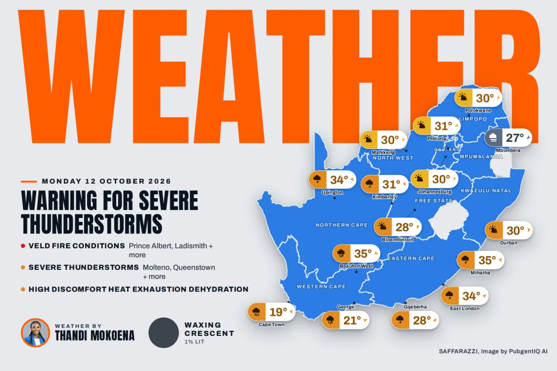
Warning for Severe Thunderstorms. It’s a warm Monday across much of South Africa, with partly cloudy skies over Johannesburg, Polokwane and Mahikeng as temperatures climb to around 30C, while Kimberley leads the way at 31C with showers and thundershowers, a pattern shared by Gqeberha, which reaches 28C. Cape Town is the cool exception at 14 to 19C with slight rain, Durban stays balmy at up to 30C, and Mbombela starts the day under fog before reaching 27C. The South African Weather Service has issued six warnings for extreme veld fire conditions, so please take care with any open flames and report fires quickly.
ADVERTISEMENT
⚠️ Weather Warnings
Yellow level 2Severe ThunderstormsMolteno, Queenstown, Grahamstown + 26 more · from 15:00 on Monday 12 October, valid until 23:59 on 12 October▼
Areas
Molteno
Queenstown
Grahamstown
Libode
Lady Frere
Tsolo
Elliot
Peddie
Somerset East
Tarkastad
Mthatha
Adelaide
Fort
Jamesto
Jansenville
Stutterheim
Barkly East
Cofimvaba
East london
Graaff – Reinet
Komga
Burgersdorp
Dutywa
Maclear
Butterworth
Addo
Ngcobo
Port Alfred
Cradock
Expected impacts
Localised damage to settlements, property, temporary structures.
Localised disruption to power and communication supply.
Localised flooding.
Loss of livestock and crops.
Danger to life.
What to do: If possible avoid traveling, stay indoors away from metal objects.
Secure lose objects before thunderstorms start.
Do not seek shelter under trees or tall objects.
Do not cross flooded areas.
Keep listening for updates.
Warning AdvisoryWeather AdvisoryWillowmore, Grahamstown, Peddie + 14 more · valid until 21:59 on 12 October▼
Areas
Willowmore
Grahamstown
Peddie
Mthatha
Patensie
Port Elizabeth
East london
Joubertina
Komga
Dutywa
Butterworth
Bizana
Addo
Port Alfred
Libode
Lusikisiki
Port St Johns
Expected impacts
High discomfort
Heat exhaustion
Dehydration.
What to do: Drink lots of liquids and stay in shaded areas with lots of ventilation.
Do not keep elderly and children inside the cars.
Red level 10Veld Fire ConditionsPrince Albert, Ladismith, Beaufort West + 15 more · from 08:00 on Monday 12 October, valid until 18:59 on 12 October▼
Areas
Prince Albert
Ladismith
Beaufort West
Sutherland
Laingsburg
Victoria West
Noupoort
Vryburg
Barkly West
Jan Kempdorp
Molteno
Queenstown
Lady Frere
Tarkastad
Jamesto
Graaff – Reinet
Burgersdorp
Cradock
Expected impacts
Conditions are such that the FDI index is above 75. Under these conditions fires may develop and spread rapidly resulting in damage to property and possible loss of human and/or animal life.
What to do ▼
All personnel and equipment should be removed from the field. Fire teams, labour and equipment are to be placed on full stand-by. At first sign of smoke, every possible measure should be taken in order to bring the fire under control in the shortest possible time. All available aircraft are to be called for without delay.
Weather Advisories
1 itemImpact-Based WarningsYellow level 2 Warning for Severe Thunderstorms resulting in localised damage to settlements, property and localised…▼
Yellow level 2 Warning for Severe Thunderstorms resulting in localised damage to settlements, property and localised disruption to communication and power supply are expected over the Eastern Cape (except in the extreme north-east).
1 itemFire Danger WarningsExtremely high fire danger conditions are expected in places over the Northern Cap, Naledi municipality of North-West…▼
Extremely high fire danger conditions are expected in places over the Northern Cap, Naledi municipality of North-West, in places over the Eastern Cape as well as the in places over King Cetshwayo District of KwaZulu Natal.
2 itemsAdvisoriesA heat wave with persistently high temperatures is expected in places in the north-western parts of KwaZulu Natal until…▼
A heat wave with persistently high temperatures is expected in places in the north-western parts of KwaZulu Natal until Tuesday (11-13/10/2026).
Extremely uncomfortable conditions are expected in places over the southern parts of the Eastern Cape.
Moon Phase
🌒 Moon phase: Waxing Crescent: a slim sliver of the Moon is lighting up as it grows towards full – traditionally a time for setting intentions.
The Moon is about 1% illuminated tonight, on day 0.8 of its 29.5-day cycle. It rises at 06:45 and sets at 21:02 (SAST). Next full moon: Monday 26 October · next new moon: Monday 9 November.
Today’s Weather by Province
All nine provinces follow, each with today’s weather, wind, rain chance and its towns. Gauteng is open below; tap any other province to open its forecast.
Rain30%WindNNW 15 km/hFeels15°Humidity75-85%UVLowAir qualityModerate (56)Cloud75%Sun06:07 – 18:57TidesH 03:55 · L 09:53 · H 16:05 · L 22:15Sea15.4°C · 1.92 m waves · 10.45 s swell
SAWS outlook: Morning fog patches is expected along the coast, otherwise cloudy, windy and cool to warm but hot over the north-eastern parts, with isolated rain and showers from the afternoon except over the north-west. The wind along the coast will be light to moderate north-westerly to westerly, becoming moderate to fresh south-westerly along the south coast from the late afternoon. The expected UVB sunburn index: Very High.
Rain0%WindNNE 15 km/hFeels29°Humidity65-80%UVLowAir qualityFair (38)Cloud25%Sun05:20 – 18:03TidesH 04:12 · L 10:14 · H 16:25 · L 22:36Sea22.1°C · 1.98 m waves · 7.45 s swell
SAWS outlook: Morning fog over the northern interior, otherwise partly cloudy and warm to hot with isolated showers and thundershowers in places in the south and west. The wind along the coast will be moderate to fresh northerly to north-easterly. The expected UVB sunburn index: Very High.
The days ahead
Tue
24°/22°
Wed
25°/21°
Thu
28°/21°
Fri
27°/23°
Sat
25°/22°
Sun
23°/20°
Around the province
Pietermaritzburg36°/18°Showers and Thundershowers · NNW 5 km/h
Rain60%WindSW 15 km/hFeels27°Humidity80-95%UVLowAir qualityModerate (46)Cloud100%Sun05:38 – 18:28TidesH 04:11 · L 10:07 · H 16:23 · L 22:30Sea16.1°C · 2.0 m waves · 10.8 s swell
SAWS outlook: Western half: Morning fog south of the escarpment, otherwise Partly cloudy and warm, but hot over the with scattered afternoon and evening thunderstorms. The wind along the coast will be light north-westerly becoming moderate south-westerly from late morning. Eastern half: Partly cloudy and hot with isolated thunderstorms but scattered in the extreme west. The wind along the coast will be moderate north-easterly becoming moderate to fresh south-westerly in the afternoon.
The days ahead
Tue
18°/16°
Wed
21°/16°
Thu
21°/16°
Fri
22°/16°
Sat
19°/17°
Around the province
East London34°/19°Showers and Thundershowers · SW 10 km/h
Mthatha35°/18°Showers and Thundershowers · NNW 5 km/h
Queenstown31°/15°Showers and Thundershowers · NW 15 km/h
SAWS outlook: Cloudy in the east at first with early morning fog patches along the escarpment, otherwise, partly cloudy and warm but hot in places in the Limpopo Valley and the Western Bushveld.
Rain30%WindNNW 15 km/hFeels28°Humidity20-50%UVModerateAir qualityPoor (62)Cloud50%Sun05:46 – 18:28TidesH 03:15 · L 09:09 · H 15:24 · L 21:33Sea13.5°C · 1.8 m waves · 10.6 s swell
SAWS outlook: Partly cloudy, windy and warm to hot, with isolated showers and thundershowers over the east and central. The wind along the coast will be light and variable becoming moderate north-westerly from the afternoon.
The days ahead
Tue
26°/19°
Wed
31°/17°
Thu
34°/17°
Fri
35°/20°
Sat
34°/21°
Around the province
Upington34°/23°Showers and Thundershowers · NW 15 km/h
Springbok24°/16°Cloudy · W 10 km/h
De Aar30°/20°Showers and Thundershowers · NW 15 km/h