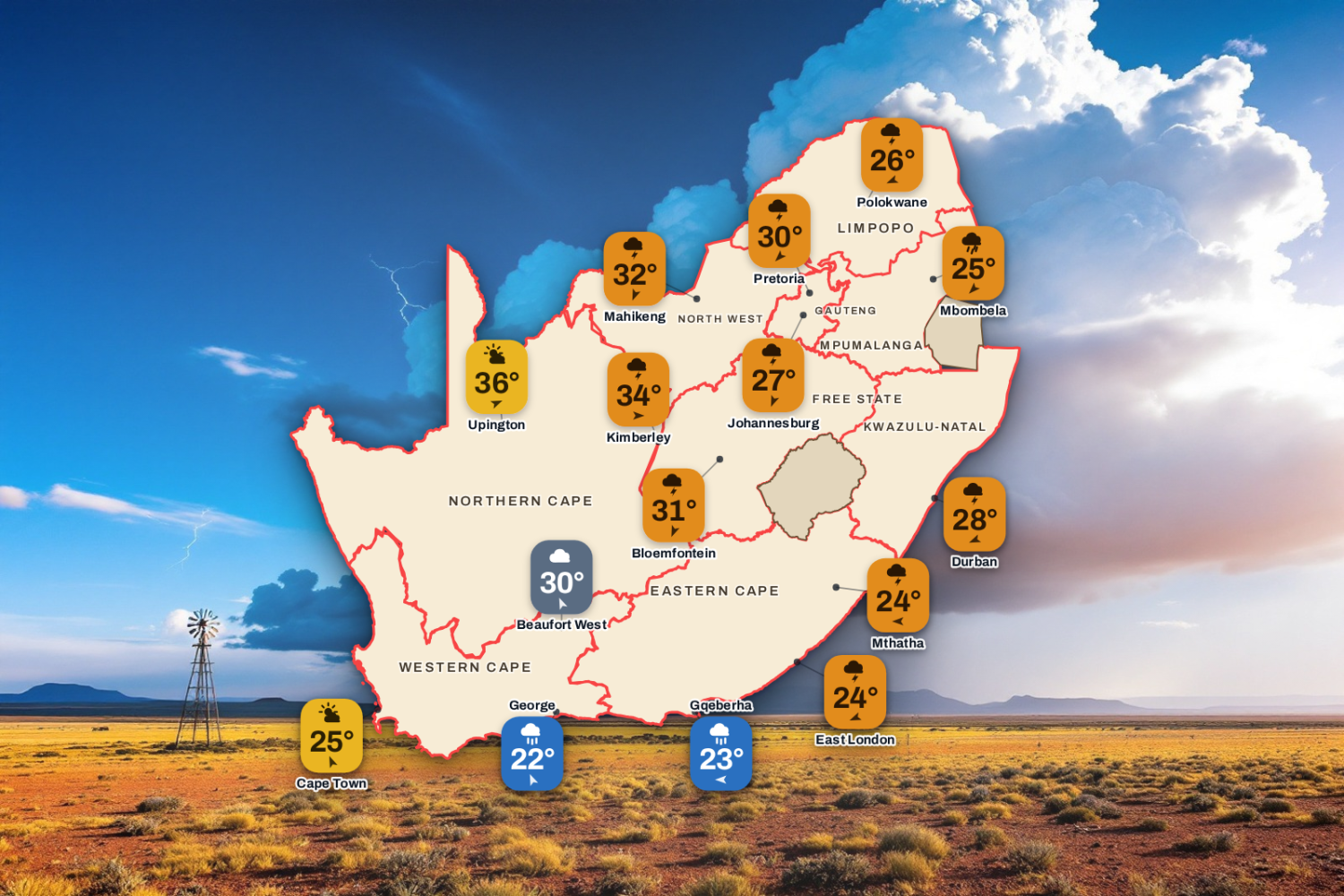
Today's highs and lows across the country, with SAWS warnings and the moon phase. Visuals by PubgentIQ AI
Updated Sunday 15 November 2026, 14:59 SAST
Warning for Severe Thunderstorms. Today’s weather for 34 towns across the nine provinces: the sky, the high and the low, the chance of rain and the wind, town by town.
Advertisement
Weather Warnings Today
Orange level 5
Severe Thunderstorms
Escourt, Ekuvukeni, Ladysmith + 24 more · valid until 23:59 on 15 November
▼
Areas
Escourt
Ekuvukeni
Ladysmith
Dannhauser
Underberg
Paulpietersburg
Utrecht
Dundee
Kokstad
Impendle
Donnybrook
Abaqulusi
Goodhom
Giants Castle
Mooi River
Pomeroy
Newcastle
Nkandla
Nongoma
Nqutu
Royal National Park
Ulundi
Howick
New Hanover
Greytown
Umzimkhulu
uPhongolo
Expected impacts
Flooding of settlements which may lead to displacement of affected communities.
Danger to life due to fast-flowing river streams.
Mudslides, rockfalls and soil erosion.
Flooding of roads and damage to bridges which may lead to road closure and the disruption of traffic flow.
Potential disruption of essential services (e.g. water, electricity and communication networks).
Large amounts of small hail/ large hail over an open area.
Lightning resulting in localised fire incidents.
What to do ▼
Where it is reasonable, stay in doors and off the road (in the road stretch where there may be sinkholes and/or potholes),
Avoid crossing swollen rivers and streams and if trapped in floods, leave the vehicle and climb to the higher ground,
In buildings (at home), place valuables above the expected flood level where they will be safe,
In rural areas, protect, relocate animals to a safe, higher ground,
Contact authorities from disaster management where things become uncontrollable.
Orange level 5
Severe Thunderstorms
Standerton, Piet Retief, Barberton + 6 more · valid until 23:59 on 15 November
▼
Areas
Standerton
Piet Retief
Barberton
Ermelo
Amersfoort
Secunda
Carolina
Machadodorp
Middelburg
Expected impacts
Falling trees blocking minor roads.
Flooding.
Service disruption due to power surges/disruptions
Damage to vehicles and structures
Hazardous driving conditions.
What to do: Seek safe shelter from hail.
Drive carefully.
Stay away from flooded areas.
Orange level 5
Severe Thunderstorms
Frankfort, Reitz, Van Reenen + 2 more · from 16:00 on Sunday 15 November, valid until 21:59 on 15 November
▼
Areas
Frankfort
Reitz
Van Reenen
Warden
Bohlokong
Expected impacts
Flooding of roads, settlements and low-lying areas, resulting in closure of some bridges and roads.
Damages or loss of infrastructure, settlements, vehicles, livelihood and livestock.
Danger to life (fast flowing streams / deep water).
Disruption to municipal and other essential services.
Major travel disruptions.
What to do ▼
If possible stay indoors away from metal objects. Do not seek shelter under trees or tall objects. Do not go fishing or play golf as both the golf clubs and fishing rods are a good conductor of electricity. Avoid any unnecessary travel. Do not cross swollen rivers/streams and/or flooded roads and bridges. Keep an eye on the SAWS website for any updates regarding severe thunderstorm development and movement. Emergency services be on high alert.
Yellow level 2
Damaging Winds
Hluhluwe, M8 Cape Vidal, M5 Mtunzini + 4 more · from 10:00 on Monday 16 November, valid until 23:59 on 17 November
▼
Areas
Hluhluwe
M8 Cape Vidal
M5 Mtunzini
M7 Nhlabane
Riverview
M6 Richards Bay
Mbazwana
Expected impacts
Localised disruption of small harbours and/or a port for a short period of time
Difficulty in navigation (eg. Hampered progress due to strong winds)
Small vessels at risk of taking on water and capsizing in a locality.
Localised disruptions to beachfront activities.
Localised damage to settlements (formal and informal).
Localised problems for high-sided vehicles on prone routes.
What to do: Small to medium boats are advised to stay away from the open sea and seek the shelter of a harbour. In the harbour, moor the boats properly with ample fenders. Avoid going to beaches. Drive with caution, especially high-sided vehicles and trucks. Secure or bring indoors loose items such as chairs, bins, signs and roof sheets.
1 further warning in force; see the SAWS warnings feed.
The South African Weather Service issues impact-based warnings. They say what the weather could do to people, roads and homes, not only how strong it will be. Each warning has a colour and a level from 1 to 10.
Yellow (Levels 1 to 4): minor to moderate impact. Local disruption such as flooded streets, travel delays or damage to informal homes. Stay alert.
Orange (Levels 5 to 8): significant impact. Major travel problems, power cuts, flooding in low-lying areas and damage to property are likely. Prepare and take action.
Red (Levels 9 and 10): severe impact. Widespread flooding, washed-away roads, damaged buildings and danger to life. Take emergency precautions at once.
The number also reflects how likely the impact is, so two warnings of the same colour can differ in how likely they are to happen. Always follow SAWS and your local disaster management.
Forecast data: South African Weather Service (weathersa.co.za) and various 3rd party providers and AI Tools.
Enjoyed this story? We need your help.
Add Saffarazzi as a preferred source. You’ll see more of our stories on Google, and you’ll help us grow.