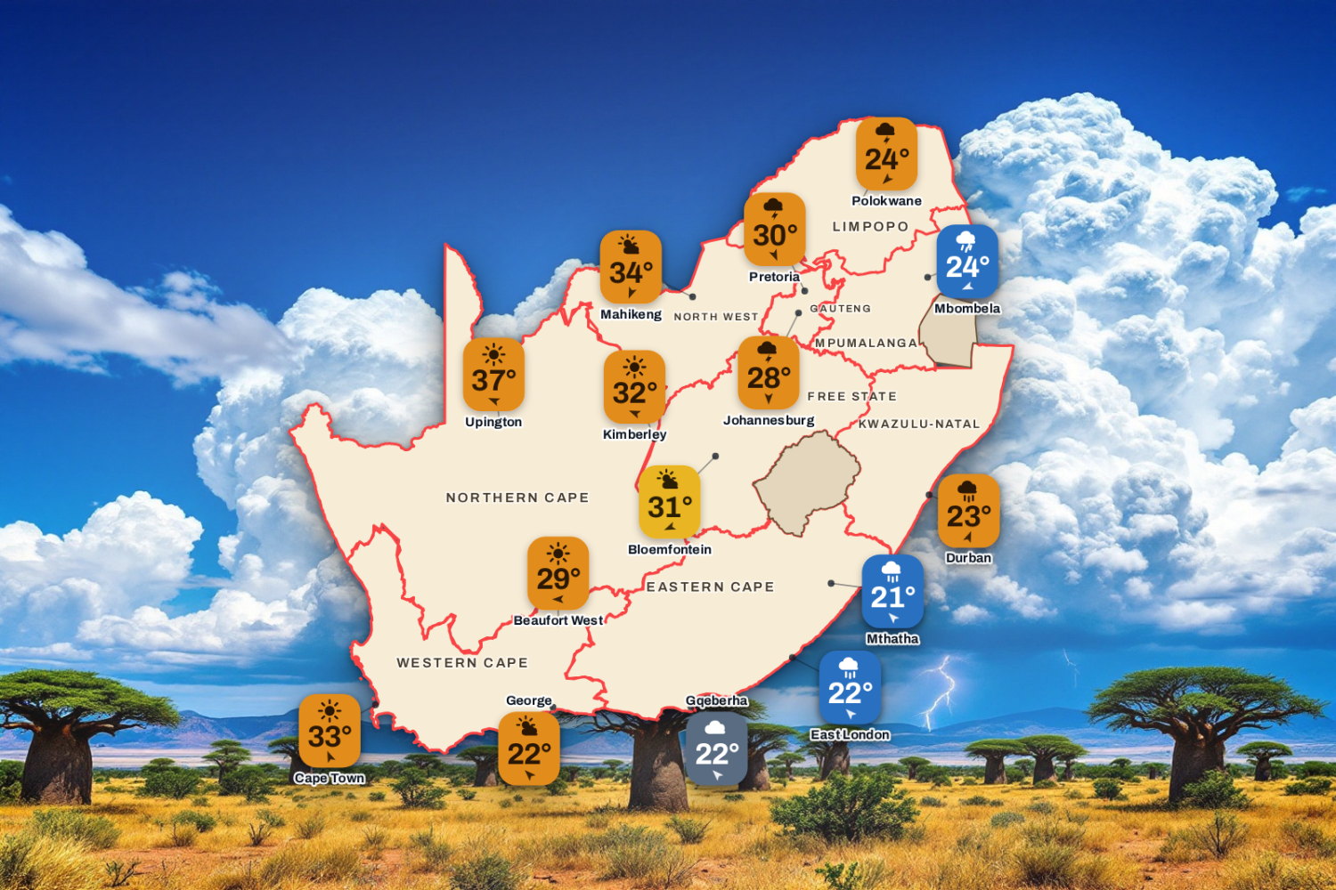
Today's highs and lows across the country, with SAWS warnings and the moon phase. Visuals by PubgentIQ AI
Updated Tuesday 17 November 2026, 05:32 SAST
Warning for Damaging Winds. Today’s weather for 34 towns across the nine provinces: the sky, the high and the low, the chance of rain and the wind, town by town.
Advertisement
Weather Warnings Today
Yellow level 2
Severe Thunderstorms
Thabazimbi, Heidelberg, Westonaria + 9 more · from 12:00 on Tuesday 17 November, valid until 23:59 on 17 November
▼
Areas
Thabazimbi
Heidelberg
Westonaria
Randfontein
Pretoria
Bela-Bela
Meyerton
Johannesburg
Kempton park
Carletonville
Krugersdorp
Vereeniging
Expected impacts
Damages to properties and settlements (formal and informal) due to wind and hail.
Localised flooding of low-water bridges, and susceptible settlements.
Disruption to power supply and communications.
What to do: Seek safe shelter from hail and lightning.
Drive carefully.
Stay away from flooded areas.
Load WeatherSmart APP, scroll to last page and use two fingers to navigate storm tracking application.
Yellow level 2
Damaging Winds
Hluhluwe, M8 Cape Vidal, M5 Mtunzini + 5 more · valid until 23:59 on 17 November
▼
Areas
Hluhluwe
M8 Cape Vidal
M5 Mtunzini
M7 Nhlabane
Riverview
M6 Richards Bay
Mbazwana
Richards Bay
Expected impacts
Localised disruption of small harbours and/or a port for a short period of time
Difficulty in navigation (eg. Hampered progress due to strong winds)
Small vessels at risk of taking on water and capsizing in a locality.
Localised disruptions to beachfront activities.
Localised damage to settlements (formal and informal).
Localised problems for high-sided vehicles on prone routes.
What to do: Small to medium boats are advised to stay away from the open sea and seek the shelter of a harbour. In the harbour, moor the boats properly with ample fenders. Avoid going to beaches. Drive with caution, especially high-sided vehicles and trucks. Secure or bring indoors loose items such as chairs, bins, signs and roof sheets.
Yellow level 1
Damaging Winds
Table Bay, Cape Point, Cape Agulhas 1 + 1 more · valid until 23:59 on 17 November
▼
Areas
Table Bay
Cape Point
Cape Agulhas 1
Hermanus
Expected impacts
Localised damage to settlement (both informal and formal) and temporary structures.
Localised difficulty in navigation at sea.
Risk of localised runaway fires.
What to do: The public is advised to secure loose objects and structures, roof sheets, signage and outdoor furniture. (e.g. closing of windows, covering of sand, Watering of the dampening of sand). Stay away from flying debris that may pose danger. Monitor the latest SAWS warnings and follow instructions from local authorities.
Advisory
Heat Advisory
Grabouw, Worcester, Prince Albert + 21 more · from 00:00 on Wednesday 18 November, valid until 23:59 on 19 November
▼
Areas
Grabouw
Worcester
Prince Albert
Swellendam
Riversdale
Robertson
Beaufort West
Ladismith
Oudtshoorn
Laingsburg
Garies
Pofadder
Springbok
Paarl
Redelinghuys
Ceres
Calvinia
Malmesbury
Cape Town city
Vredendal
Langebaan
Clanwilliam
Stellenbosch
Sutherland
Expected impacts
When the temperature is extremely high, humans’ ability to cool their bodies through sweating is reduced. This can be a real threat that may lead to hyperthermia.
In an extremely hot environment, the most serious health and safety concern is heat stroke. Heat stroke can be fatal if medical attention is not available immediately.
What to do: Avoid prolonged direct exposure to the sun as far as possible and stay hydrated. If possible, remain in shaded or cool areas, carry umbrellas, during the hottest part of the day especially during the queuing to cast your vote for the local elections. Limit strenuous outdoor activities. Never leave kids in the car unattended. Make sure your animals have access to enough water. Check on vulnerable individuals, including the elderly and young children.
1 further warning in force; see the SAWS warnings feed.
The South African Weather Service issues impact-based warnings. They say what the weather could do to people, roads and homes, not only how strong it will be. Each warning has a colour and a level from 1 to 10.
Yellow (Levels 1 to 4): minor to moderate impact. Local disruption such as flooded streets, travel delays or damage to informal homes. Stay alert.
Orange (Levels 5 to 8): significant impact. Major travel problems, power cuts, flooding in low-lying areas and damage to property are likely. Prepare and take action.
Red (Levels 9 and 10): severe impact. Widespread flooding, washed-away roads, damaged buildings and danger to life. Take emergency precautions at once.
The number also reflects how likely the impact is, so two warnings of the same colour can differ in how likely they are to happen. Always follow SAWS and your local disaster management.
Forecast data: South African Weather Service (weathersa.co.za) and various 3rd party providers and AI Tools.
Enjoyed this story? We need your help.
Add Saffarazzi as a preferred source. You’ll see more of our stories on Google, and you’ll help us grow.