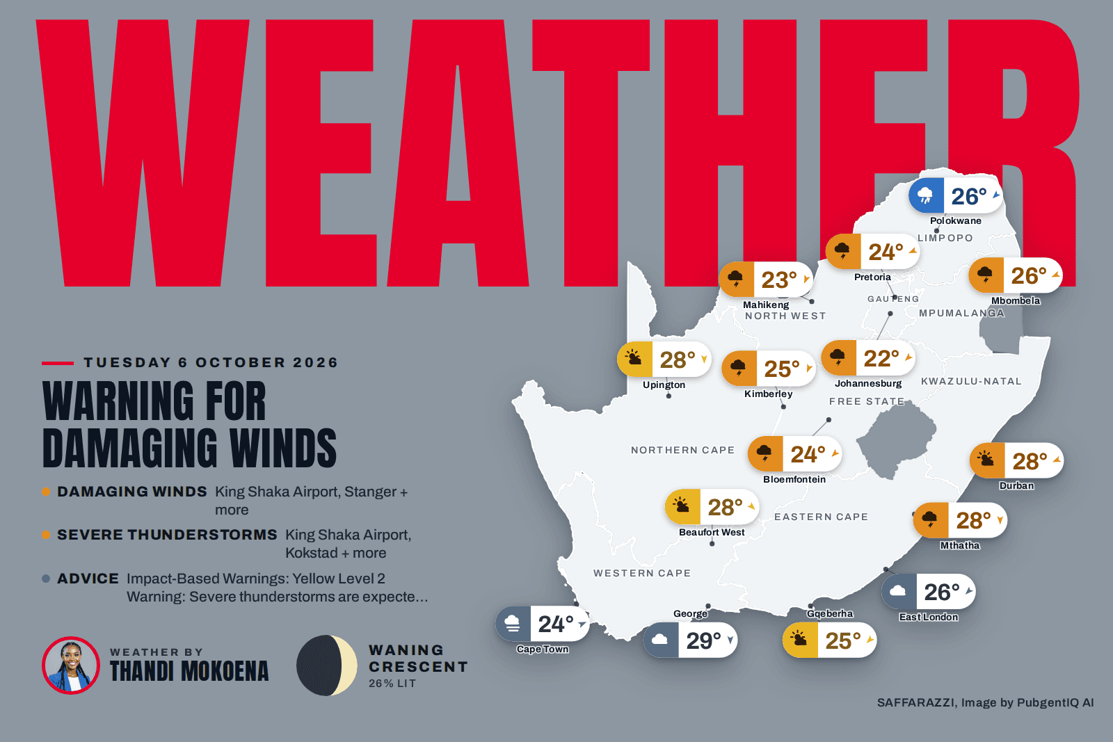
Warning for Damaging Winds. Showers and thundershowers are set to dominate much of South Africa’s interior this Tuesday, with Johannesburg, Bloemfontein, Mbombela, Mahikeng and Kimberley all in line for unsettled skies, while Polokwane can expect rain showers and Johannesburg starts off cool at 10C before reaching 22C. Along the coast, conditions look calmer, with partly cloudy skies over Durban, the warmest of the major centres at 28C, and Gqeberha, while Cape Town wakes to mist ahead of a pleasant 24C. The South African Weather Service has issued several minor warnings for damaging winds, so it is worth securing loose items and keeping an eye on local updates as the day unfolds.
⚠️ Weather Warnings
Yellow level 2Damaging WindsKing Shaka Airport, Stanger, Mandini + 13 more · from 17:00 on Tuesday 6 October, valid until 23:59 on 7 October▼
Areas: King Shaka Airport, Stanger, Mandini, M3 Durban, M4 Tugela Mouth, M5 Mtunzini, M7 Nhlabane, M1 Port Shepstone, Riverview, M2 Scottburgh, M6 Richards Bay, Margate, Pennington, Richards Bay, Eshowe, St Faith's (Cathula).
Risk of localised runaway fire.
Localised problems for high-sided vehicles on prone routes e.g. due to cross winds on exposed high
level roads/bridges
Some journeys require longer travel times
Localised loss of agricultural production
What to do: The public is advised to take necessary precautions.
Yellow level 2Severe ThunderstormsKing Shaka Airport, Kokstad, Donnybrook + 9 more · from 18:00 on Tuesday 6 October, valid until 23:59 on 6 October▼
Areas: King Shaka Airport, Kokstad, Donnybrook, Camperdown, Margate, Richmond, Pietermaritzburg, Ixopo, Pennington, Harding, Umzimkhulu, St Faith's (Cathula).
Localised damage to infrastructure and settlements.
Localised flooding of susceptible roads and bridges.
Minor motor vehicle accidents due to slippery roads and poor visibility.
Difficult driving conditions on dirt and slippery roads.
Large amounts of small hail/ large hail over an open area.
Localised fire incidents.
What to do: Take caution or avoid traveling on bridges and roads in low lying areas as these may be susceptible to flooding and there may be sinkholes. Avoid outdoor activities as lightning, hail and flooding may result in injuries and death. If possible, stay indoors well clear of windows, shelter pets, and cover vehicles. Move livestock and cars to safe sheltered areas as there may be flying debris.
Weather Advisories
3 itemsImpact-Based WarningsYellow Level 2 Warning: Severe thunderstorms are expected over the south-eastern parts of KwaZulu-Natal, which may…▼
Yellow Level 2 Warning: Severe thunderstorms are expected over the south-eastern parts of KwaZulu-Natal, which may result in heavy downpours, damaging winds, hail and excessive lightning. These may lead to localised flooding of susceptible roads, low-lying areas and bridges, and localised damage to settlement and infrastructure.
Yellow Level 2 Warning: Damaging Winds are expected along the coast and adjacent interior between Port Edward and Richards Bay resulting in localised damage to settlements, disruption to beachfront activities and difficulty in navigation.
Yellow Level 1 Warning: Damaging Waves leading to difficulty in navigation at sea and small vessels at risk of capsizing are expected between Cape Columbine and Cape Agulhas, spreading to Alexander Bay in the north and Plettenberg Bay in the east by the evening and persisting into Thursday (06-08/10/2026).
Moon Phase
🌘 Moon phase: Waning Crescent: only a thin sliver remains before the next New Moon – the quietest tail of the cycle.
The Moon is about 26% illuminated tonight, on day 24.5 of its 29.5-day cycle. It rises at 03:13 and sets at 13:32 (SAST). Next full moon: Monday 26 October · next new moon: Sunday 11 October.
Rain0%WindWSW 5 km/hFeels24°Humidity60-85%UVLowAir qualityModerate (43)Cloud5%Sun06:16 – 18:52TidesH 00:10 · L 06:21 · H 12:34 · L 19:00Sea14.2°C · 4.06 m waves · 12.35 s swell
SAWS outlook: Cloudy to partly cloudy and cool to cold with isolated to scattered showers and rain over the western parts spreading to the eastern parts from mid-morning and clearing in the west from the afternoon. The wind along the coast will be moderate to fresh westerly to south – westerly reaching strong to near gale along the south and south -west coast in the morning. The expected UVB sunburn index: Moderate.
Rain0%WindENE 10 km/hFeels28°Humidity65-85%UVHighAir qualityModerate (57)Cloud50%Sun05:28 – 17:59TidesH 00:47 · L 06:57 · H 13:20 · L 19:36Sea22.4°C · 1.84 m waves · 8.1 s swell
SAWS outlook: Morning fog over the interior, otherwise fine and warm to hot becoming cloudy in the afternoon with isolated showers and thundershowers but scattered in the south. The wind along the coast will be moderate easterly to north-easterly, but fresh to strong north of Mandeni at times. It will become fresh to strong south-westerly from the south towards evening, reaching Richards Bay overnight. The expected UVB sunburn index: High AND OR.
The days ahead
Wed
20°/18°
Thu
23°/18°
Thu
23°/18°
Sat
24°/21°
Sun
26°/21°
Mon
26°/21°
Around the province
Pietermaritzburg28°/10°Partly cloudy · E 5 km/h
Richards Bay31°/17°Slight rain · E 5 km/h
Newcastle27°/10°Showers and Thundershowers · ENE 5 km/h
Rain0%WindNE 10 km/hFeels25°Humidity55-90%UVLowAir qualityModerate (43)Cloud75%Sun05:48 – 18:23TidesH 00:29 · L 06:51 · H 13:00 · L 19:30Sea14.0°C · 3.1 m waves · 9.25 s swell
SAWS outlook: Western half: Warm in places at first, otherwise partly cloudy and cool, becoming cloudy and windy from the west with isolated to scattered showers and thundershowers, showers and rain along the coast. The wind along the coast will be strong south-westerly, but moderate north-westerly east of Algoa Bay at first. Eastern half: Partly cloudy and warm with scattered showers and thundershowers, becoming cloudy, windy and cool from the west in the afternoon. The wind along the coast will be light to moderate northerly at first, otherwise moderate north-easterly, becoming strong south-westerly in the south midday spreading to the east.
SAWS outlook: Cloudy in the morning with isolated showers and thundershowers in the east, but scattered in the extreme north-east, otherwise partly cloudy and warm.
Rain30%WindNNE 10 km/hFeels21°Humidity30-50%UVModerateAir qualityFair (36)Cloud50%Sun05:54 – 18:24TidesL 05:41 · H 11:50 · L 18:21Sea14.6°C · 3.5 m waves · 11.6 s swell
SAWS outlook: Cloudy to partly cloudy and cool to cold, with isolated showers and rain over the western and southern parts in the morning but thundershowers in the east. It will become fine over the north and north-western parts in the evening. The wind along the coast will be light to moderate westerly to south – westerly in the early morning, otherwise fresh to strong southerly to south-easterly.