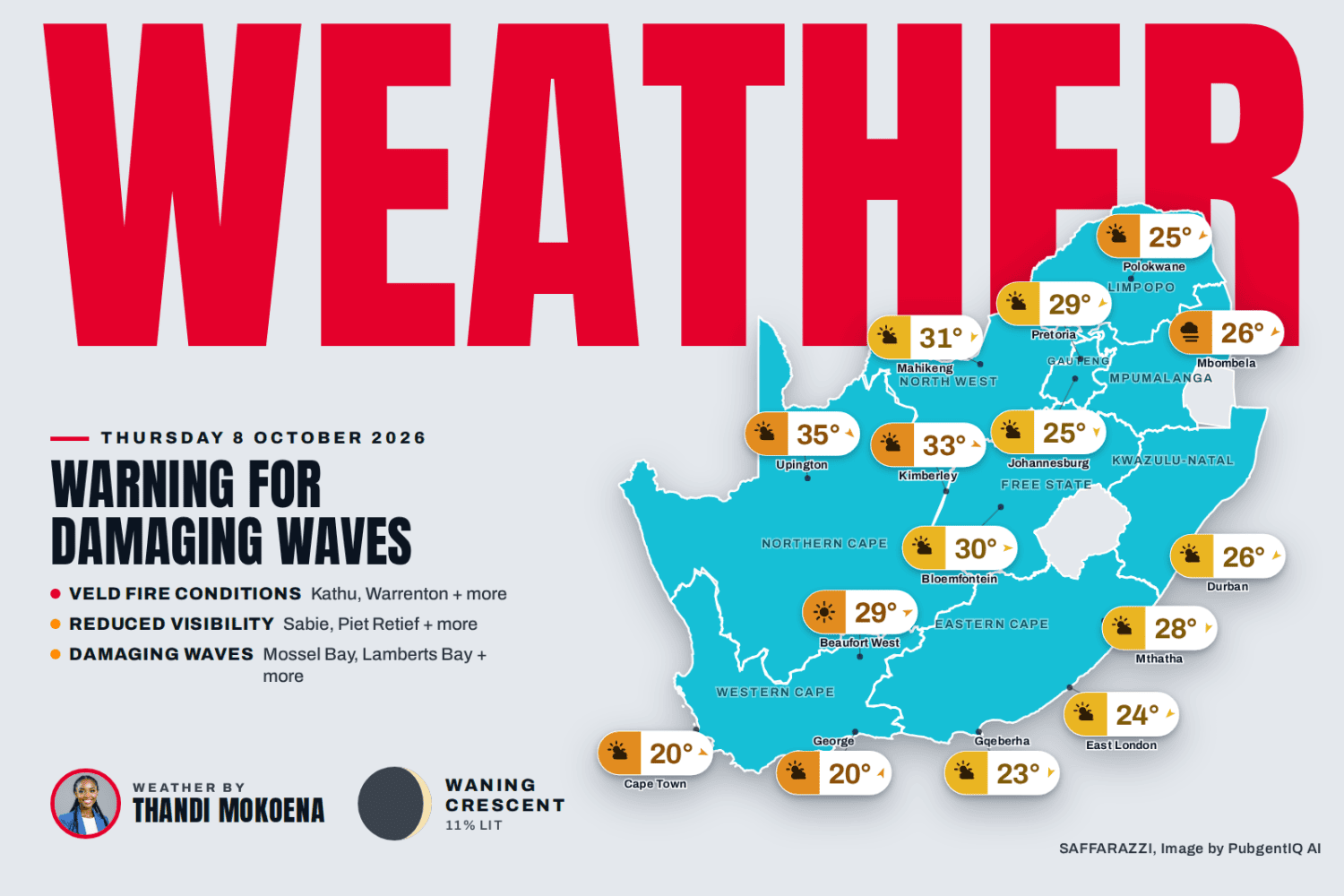
Warning for Damaging Waves. South Africa can expect a largely pleasant Thursday under partly cloudy skies, though the interior will heat up noticeably, with Kimberley reaching 33°C, Mahikeng 31°C and Bloemfontein 30°C, while Johannesburg and Polokwane stay comfortable at around 25°C. Mbombela starts the day with fog before climbing to 26°C, Durban sits between 18°C and 26°C, and the south stays milder, with Gqeberha peaking at 23°C and Cape Town reaching just 20°C under high-level cloud. The South African Weather Service has issued six warnings for extreme veld fire conditions, so please take extra care with any open flames and avoid outdoor burning today.
Advertisement
Afternoon Update: 16:31
Friday looks hot and unsettled across much of the interior, with showers and thundershowers expected in Johannesburg (13 to 31°C), Bloemfontein (14 to 31°C), Mahikeng (17 to 32°C) and Kimberley, which tops the charts at a sweltering 35°C. Further east it stays dry but very warm under partly cloudy skies, with Mbombela reaching 34°C and Polokwane 32°C, while Durban can expect slight rain and a muggy 20 to 28°C, Gqeberha a pleasant partly cloudy 12 to 23°C, and Cape Town a mild 12 to 20°C beneath high-level cloud. The South African Weather Service has issued several warnings for extreme veld fire conditions, so please take extra care with any open flames and report fires immediately.
⚠️ Weather Warnings TL;DR
Veld Fire Conditions (Warning Level 10) – Kathu, Warrenton and 5 more areas, valid until 18:59 on 8 October.
Damaging Waves (Warning Level 1) – Mossel Bay, Lamberts Bay and 16 more areas, valid until 23:59 on 8 October.
Tomorrow brings a lively, varied day across South Africa, with showers and thundershowers expected over Gauteng and the Free State, slight rain in KwaZulu-Natal, and calmer, cloud-dappled skies over the Cape provinces. Gauteng and the Free State will be warmest at 31C, while the Western and Eastern Cape start coolest at 12C.
Town
Min / Max
Conditions
Pretoria
14° / 33°C
Partly cloudy with isolated showers and thundershowers. UVB Sunburn Index: High
Johannesburg
13° / 32°C
Partly cloudy with isolated showers and thundershowers.
Vereeniging
13° / 32°C
Partly cloudy with isolated showers and thundershowers.
Mbombela
15° / 34°C
Fine with morning fog patches, becoming partly cloudy with isolated showers and thundershowers.
Polokwane
15° / 32°C
Fine with morning fog patches, becoming partly cloudy with isolated showers and thundershowers.
Mahikeng
17° / 32°C
Fine becoming partly cloudy with isolated showers and thundershowers.
Vryburg
18° / 32°C
Fine becoming partly cloudy with isolated showers and thundershowers.
Bloemfontein
14° / 32°C
Fine becoming partly cloudy with isolated showers and thundershowers.
Kimberley
17° / 35°C
Fine becoming partly cloudy with isolated showers and thundershowers.
Upington
16° / 34°C
Fine.
Cape Town
12° / 20°C
Fine with high-level clouds, becoming partly cloudy from late morning. Wind: Moderate north to north-westerly, becoming southerly from late afternoon. UVB Sunburn Index: Moderate
George
11° / 20°C
Fine with high-level clouds, becoming cloudy from late afternoon. Wind: Light north-westerly, becoming southerly from late morning, while easterly from late evening.
Gqeberha
12° / 23°C
Fog in the morning, otherwise fine. Wind: Light to moderate south-westerly.
KuGompo City
15° / 21°C
Fine. Wind: Light to moderate south-westerly.
Durban
20° / 28°C
Fine, becoming partly cloudy to cloudy with isolated showers and rain in the afternoon. Wind: Light north-westerly in the morning, otherwise moderate to fresh south-westerly. UVB Sunburn Index: High
Richards Bay
20° / 33°C
Fine, becoming cloudy in the afternoon. Wind: Light north-westerly in the morning, otherwise moderate to fresh north-east becoming south-westerly from late morning.
Pietermaritzburg
15° / 33°C
Morning fog patches, otherwise fine becoming cloudy with isolated showers and thundershowers in the afternoon. African Weather Service)
Source: South African Weather Service travellers forecast.
⚠️ Weather Warnings
Red level 10Veld Fire ConditionsKathu, Warrenton, Kimberley + 4 more · from 08:00 on Thursday 8 October, valid until 18:59 on 8 October▼
Areas: Kathu, Warrenton, Kimberley, Kuruman, Taung, Barkly West, Jan Kempdorp.
Expected impacts
Conditions are such that the FDI index is above 75. Under these conditions fires may develop and spread rapidly resulting in damage to property and possible loss of human and/or animal life.
What to do ▼
All personnel and equipment should be removed from the field. Fire teams, labour and equipment are to be placed on full stand-by. At first sign of smoke, every possible measure should be taken in order to bring the fire under control in the shortest possible time. All available aircraft are to be called for without delay.
Yellow level 2Reduced VisibilitySabie, Piet Retief, Barberton + 21 more · valid until 09:59 on 8 October▼
Difficult driving conditions which may cause road traffic accidents and longer travel times.
What to do: Keep the headlights and hazard lights on (not bright light), reduce speed and be extra cautious of other motorists.
Yellow level 1Damaging WavesMossel Bay, Lamberts Bay, Saldanha Bay + 15 more · valid until 23:59 on 8 October▼
Areas: Mossel Bay, Lamberts Bay, Saldanha Bay, Kleinzee, Hondeklip Bay, Port Nolloth, Table Bay, George, Cape Point, Cape Columbine, Strandfontein, Cape Agulhas 1, Hermanus, Cape Agulhas 2, Still Bay, Plettenberg Bay, Knysna, Dassen Island.
Localised disruptions of small harbours or ports are possible.
Difficulty in navigation for small vessels and personal water craft is likely which may lead to vessels being at risk of taking on water and capsizing.
Localised disruption to beachfront activities.
What to do: Be aware of large unpredictable waves along the coast. Small vessels are advised to seek shelter in harbours, bays or inlets.
Weather Advisories
1 itemFire Danger WarningsExtremely high fire danger conditions are expected in places over the north -eastern parts of the Northern Cape, as…▼
Extremely high fire danger conditions are expected in places over the north -eastern parts of the Northern Cape, as well as the Greater Taung Local Municipality in the North West.
Moon Phase
🌘 Moon phase: Waning Crescent: only a thin sliver remains before the next New Moon – the quietest tail of the cycle.
The Moon is about 11% illuminated tonight, on day 26.3 of its 29.5-day cycle. It rises at 04:52 and sets at 16:53 (SAST). Next full moon: Monday 26 October · next new moon: Sunday 11 October.
Advertisement
Today’s Weather by Province
All nine provinces follow, each with today’s weather, wind, rain chance and its towns. Gauteng is open below; tap any other province to open its forecast.
Rain0%WindWNW 10 km/hFeels18°Humidity55-85%UVLowAir qualityModerate (52)Cloud5%Sun06:12 – 18:54TidesH 01:46 · L 07:49 · H 13:58 · L 20:18Sea14.6°C · 3.74 m waves · 13.0 s swell
SAWS outlook: Fine and cool to warm, becoming partly cloudy along the south -east coast in the evening. The wind along the coast will be moderate south-westerly along the west and south coast but north-westerly in the south-west. The expected UVB sunburn index: Very High.
Rain0%WindNE 15 km/hFeels24°Humidity75-90%UVModerateAir qualityModerate (41)Cloud100%Sun05:25 – 18:01TidesH 02:15 · L 08:19 · H 14:32 · L 20:45Sea21.8°C · 1.98 m waves · 10.15 s swell
SAWS outlook: Morning fog patches over the interior, otherwise partly cloudy and warm to hot. The wind along the coast will be light to moderate south-westerly north of Richards Bay at first, otherwise moderate to fresh easterly to north-easterly, but strong north of Durban at times. The expected UVB sunburn index: Extreme AND/OR.
Rain0%WindSW 10 km/hFeels22°Humidity70-85%UVLowAir qualityFair (40)Cloud75%Sun05:44 – 18:25TidesH 02:06 · L 08:12 · H 14:22 · L 20:41Sea14.4°C · 2.98 m waves · 12.25 s swell
SAWS outlook: Western half: Morning fog patches in places over the interior, otherwise fine and warm. The wind along the coast will be light and variable, becoming light to moderate south – westerly. Eastern half: Morning fog in places along the escarpment, otherwise fine and warm. The wind along the coast will be light to moderate easterly to north -easterly,.
SAWS outlook: Cloudy with a chance of drizzle and fog patches along the escarpment and in places in the central in the morning, otherwise partly cloudy and warm.
Rain0%WindWNW 10 km/hFeels30°Humidity20-35%UVModerateAir qualityFair (35)Cloud25%Sun05:50 – 18:25TidesH 01:02 · L 07:02 · H 13:14 · L 19:30Sea12.2°C · 3.58 m waves · 13.2 s swell
SAWS outlook: Partly cloudy and windy in the east in the afternoon, otherwise fine and warm to hot but cool in places in the west. The wind along the coast will be moderate to fresh south-easterly.