


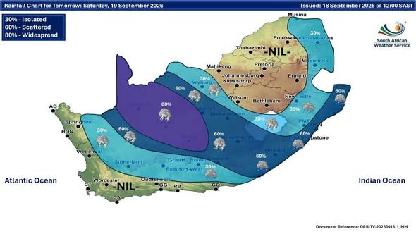
Saturday looks unsettled across much of the country, with Showers and Thundershowers building over the Free State around Bloemfontein and the Northern Cape near Kimberley, while Durban and Mbombela can expect some slight rain and cooler, damp conditions. Disruptive Rain warnings are in place, so keep an eye on the wet weather if you’re travelling through the central and eastern parts, though the Western Cape looks lovely with clear skies and a pleasant high of 24C in Cape Town, and Johannesburg stays partly cloudy and mild between 9 and 21C. Cover up if you’re out later today where those rain warnings are still active, and plan for a soggy start where the showers push through tomorrow.
The weekend, province by province
⚠️ New & Updated Weather Warnings
Severe Thunderstorms (Warning Level 5), from 00:00 on Saturday 19 September, valid until 14:59 on 19 September.
Areas: Postmasburg, Groblershoop, Kathu, Upington, Twee Rivieren, VanWyksvlei.
- Flooding of roads, settlements and low-lying areas, resulting in closure of some bridges and roads.
- Damages or loss of infrastructure, settlements, vehicles, livelihood and livestock.
- Danger to life (fast flowing streams / deep water).
- Disruption to municipal and other essential services.
- Disruption and loss of agricultural activities.
- Major travel disruptions.
Load WeatherSmart APP, scroll to last page and use two fingers to navigate storm tracking application. If possible stay indoors away from metal objects. Do not seek shelter under trees or tall objects. Do not go fishing or play golf as both the golf clubs and fishing rods are a good conductor of electricity. Be aware that any combination of hail, strong winds and/or heavy downpours that can accompany the storms. Keep an eye on the SAWS website for any updates regarding severe thunderstorm development and movement.
Severe Thunderstorms (Warning Level 4), valid until 22:59 on 18 September.
Areas: Griquastad, Warrenton, Hopetown, Kimberley, Petrusville, Barkly West.
- Flooding of roads, settlements and low-lying areas.
- Displacement of affected communities.
- Danger to life (fast flowing streams / deep water).
- Disruption to municipal and other essential services.
Drive safely and reduce speed were necessary. Do not attempt to cross flooded roads. Do not seek shelter under trees or tall objects during storms. Keep an eye on the SAWS website for any updates regarding flooding development.
Damaging Winds (Warning Level 2), valid until 18:59 on 18 September.
Areas: Mafikeng, Ratlou, Lichtenburg, Frankfort, Reitz, Victoria West, Sasolburg, Welkom, Parys, Van Reenen, Zeerust, Warden.
- Localised damage to informal settlements.
- Risk of runaway fires.
- Localised power and communication interruptions.
- Localised damage to temporary structures (e.g tents).
Take extra caution when driving, particularly high sided vehicles due to cross winds. Remove loose debris from open areas as it may be blown away. At first sign of smoke, every possible measure should be taken in order to bring the fire under control in the shortest possible time. If possible, avoid erecting temporary structures during this period.
This morning’s other warnings remain in force – full details in today’s morning forecast.
🎬 7-Day Weather Forecast Video
🗓️ Weather Warnings and Advice for the Days Ahead
Fire Danger Warnings
- Extremely high fire danger is expected over the western Bushveld in Limpopo.
Source: South African Weather Service severe weather alerts.
🌅 Tomorrow Across South Africa: Saturday 19 September
Tomorrow brings a mix across South Africa, with the Western Cape enjoying clear skies and the day’s warmest high of 24°C, while KwaZulu-Natal and the Free State see slight rain, showers, and thundershowers. Wrap up warm in Gauteng, where the coolest morning dips to a chilly 9°C.
| Town | Min / Max | Conditions |
|---|---|---|
| Pretoria | 12° / 23°C | Cloudy, becoming partly cloudy. UVB Sunburn Index: Moderate |
| Johannesburg | 9° / 21°C | Cloudy, becoming partly cloudy. |
| Vereeniging | 11° / 20°C | Cloudy, becoming partly cloudy. |
| Mbombela | 15° / 16°C | Cloudy with isolated showers and rain. |
| Polokwane | 13° / 24°C | Cloudy, becoming partly cloudy. |
| Mahikeng | 15° / 24°C | Cloudy and windy. |
| Vryburg | 15° / 22°C | Cloudy and windy with isolated showers and thundershowers. |
| Bloemfontein | 11° / 20°C | Cloudy and windy with isolated showers and thundershowers. |
| Kimberley | 12° / 20°C | Cloudy and windy with scattered showers and thundershowers. |
| Upington | 13° / 23°C | Cloudy and windy with widespread showers and thundershowers. |
| Cape Town | 14° / 24°C | Fine. Wind: Moderate south-easterly. UVB Sunburn Index: Very High |
| George | 9° / 17°C | Cloudy in the morning, otherwise partly cloudy. Wind: Light and variable. |
| Gqeberha | 14° / 21°C | Partly cloudy. Wind: Moderate north-easterly. |
| KuGompo City | 13° / 20°C | Cloudy with scattered showers and rain, becoming partly cloudy. Wind: Moderate to fresh north-easterly, becoming light and variable in the evening. |
| Durban | 15° / 21°C | Cloudy with scattered showers and rain. Wind: Light and variable becoming north-easterly. UVB Sunburn Index: Low |
| Richards Bay | 16° / 21°C | Cloudy with scattered showers and rain. Wind: Moderate to fresh south-easterly. |
| Pietermaritzburg | 10° / 19°C | Cloudy with isolated showers and rain. |
Source: South African Weather Service travellers forecast.
SAWS outlook for Saturday 19 September, province by province
- Gauteng: Cloudy and cool, becoming partly cloudy from the afternoon. It will be warm in the extreme north. The expected UVB sunburn index: Moderate.
- Western Cape: Fine over the south-western parts, otherwise cloudy to partly cloudy and cool to warm with isolated showers and thundershowers in the north-east. The wind along the coast will be moderate to fresh easterly to south-easterly but strong along the south-west coast. The expected UVB sunburn index: Very High.
- KwaZulu-Natal: Cloudy and cool with isolated showers and rain but scattered along the coast and adjacent interior. The wind along the coast will be light and variable in the south at first, otherwise moderate to fresh easterly to north-easterly. The expected UVB sunburn index: Low.
- Eastern Cape: Western half: Cloudy and cool with isolated to scattered showers and rain except along the coast and adjacent interior where it will be partly cloudy in places. The wind along the coast will be moderate to fresh north-easterly, becoming light in the afternoon. Eastern half: Cloudy and cool with scattered showers and rain, but thundershowers in the north. The wind along the coast will be moderate to fresh north-easterly.
- Free State: Cloudy, windy and cool, with isolated to scattered showers and thundershowers over the central and the western parts.
- Limpopo: Partly cloudy to cloudy and cool to warm with isolated showers and rain in the east.
- Mpumalanga: Cloudy and cool to warm with isolated showers and rain in the east, becoming partly cloudy in the west in the afternoon.
- North West: Cloudy, windy and cool to warm with isolated showers and thundershowers over the west.
- Northern Cape: Cloudy, windy and cool to warm with scattered to widespread showers and thundershowers except in the extreme western parts where it be partly and cold in places. The wind along the coast will be strong to near gale south-easterly.
Source: South African Weather Service regional forecast, issued 16:00.
From the Weather Community

Forecast data: South African Weather Service (weathersa.co.za) and various 3rd party providers and AI Tools.