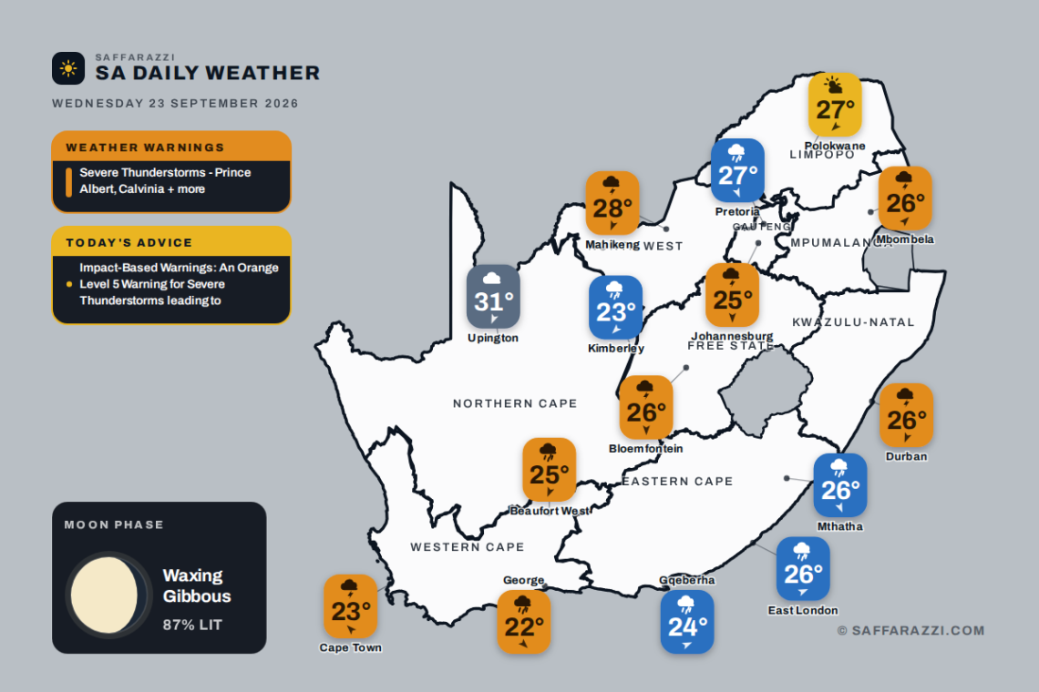
Wet and unsettled weather blankets much of South Africa today, with showers and thundershowers expected across Gauteng, the Western Cape, KwaZulu-Natal, the Free State, Mpumalanga and North West, while the Eastern Cape and Northern Cape can look forward to rain showers. Temperatures range from a cool 11 degrees in Johannesburg to a warm 28 in Mahikeng, with only Limpopo escaping the rain under partly cloudy skies. The South African Weather Service has issued several severe thunderstorm warnings, mostly of moderate severity, so keep an eye on the sky and take care on the roads through the day.
🎬 7-Day Weather Forecast Video
⚠️ Weather Warnings
Orange level 5Severe ThunderstormsPrince Albert, Calvinia, Beaufort West + 2 more · valid until 23:59 on 23 September▼
Areas: Prince Albert, Calvinia, Beaufort West, Sutherland, Laingsburg.
ADVERTISEMENT
Expected impacts
Large amounts of small hail can cause damage to infrastructure, vehicles and difficult driving conditions. These conditions can lead to major travel disruptions. Loss of livestock and agricultural productions are also likely together with disruption to essential services.
What to do ▼
If possible, stay indoors away from metal objects. Do not seek shelter under trees or tall objects. Do not go fishing or play golf, as both the golf clubs and fishing rods are a good conductor of electricity. Be aware that any combination of hail, strong winds and/or heavy downpours can accompany the storms. Stay indoors during lightning. Avoid using plumbing and touching electrical equipment connected to outlets during the storm.
Yellow level 2Severe ThunderstormsGrabouw, Worcester, Knysna + 16 more · valid until 23:59 on 23 September▼
Areas: Grabouw, Worcester, Knysna, Plettenberg Bay, Paarl, George, Swellendam, Riversdale, Ceres, Hermanus, Robertson, Cape Agulhas, Ladismith, Mosselbay, Oudtshoorn, Stellenbosch, Malmesbury, Cape Town city, Langebaan.
Localised service disruption due to power surges/disruptions
Localised injuries (human and livestock)
Localised damage to property
Localised fire incidents (dwelling/veld fire).
What to do: If possible stay indoors away from metal objects. Do not seek shelter under trees or tall objects. Do not go fishing or play golf as both the golf clubs and fishing rods are good conductors of electricity. Members of the public are therefore advised to go indoors as soon as thunder roars.
Yellow level 2Severe ThunderstormsEscourt, Ekuvukeni, Ladysmith + 15 more · from 12:00 on Wednesday 23 September, valid until 21:59 on 23 September▼
Areas: Escourt, Ekuvukeni, Ladysmith, Dannhauser, Underberg, Utrecht, Dundee, Kokstad, Impendle, Donnybrook, Goodhom, Giants Castle, Mooi River, Pomeroy, Newcastle, Royal National Park, Howick, Umzimkhulu.
Localised damage to infrastructure and settlements.
Localised flooding of susceptible roads and bridges.
Minor motor vehicle accidents due to slippery roads and poor visibility.
Difficult driving conditions on dirt and slippery roads.
Large amounts of small hail/ large hail over an open area.
What to do: Take caution or avoid traveling on bridges and roads in low lying areas as these may be susceptible to flooding and there may be sinkholes. Avoid outdoor activities as lightning, hail and flooding may result in injuries and death. If possible, stay indoors well clear of windows, shelter pets, and cover vehicles. Move livestock and cars to safe sheltered areas as there may be flying debris.
Weather Advisories
2 itemsImpact-Based WarningsAn Orange Level 5 Warning for Severe Thunderstorms leading to injuries and danger to life, large amounts of small hail…▼
An Orange Level 5 Warning for Severe Thunderstorms leading to injuries and danger to life, large amounts of small hail, damage or loss of infrastructure, settlements (formal and informal) and vehicles is expected over the Hantam, Karoo Hoogland Districts of the Northern Cape and the Central Karoo District of the Western Cape.
Yellow Level 2 Warning for Severe Thunderstorms leading to localised damage to vehicles, excessive lightning, large amounts of small hail as well as localised damage to infrastructure is expected over the Karoo Hoogland District and the southern parts of the Northern Cape, vast parts of the Western Cape (except the north and central parts of the West Coast District), and south-western and western parts of KwaZulu Natal and the southern parts of the Free State.
Moon Phase
🌔 Moon phase: Waxing Gibbous: more than half lit and still growing towards full – a building, almost-there phase.
The Moon is about 87% illuminated tonight, on day 11.3 of its 29.5-day cycle. It rises at 15:39 and sets at 04:44 (SAST). Next full moon: Saturday 26 September · next new moon: Sunday 11 October.
Rain60%WindSE 10 km/hFeels24°Humidity75-90%UVLowAir qualityExtremely poor (173)Cloud75%Sun06:33 – 18:43TidesH 00:42 · L 06:55 · H 13:02 · L 19:17Sea15.8°C · 1.38 m waves · 9.9 s swell
SAWS outlook: Morning fog along the west coast, otherwise cloudy and cool to warm with scattered showers and thundershowers but isolated over the West Coast. The wind along the coast will be moderate northerly north of Cape Columbine in the morning otherwise moderate to fresh southerly to south-easterly. The expected UVB sunburn index: Moderate.
The days ahead
Thu
21°/15°
Fri
20°/14°
Sat
20°/16°
Sun
18°/14°
Mon
20°/13°
Tue
25°/12°
Around the province
Stellenbosch22°/15°Showers and thundershowers · SW 13 km/h
Rain30%WindNNE 10 km/hFeels26°Humidity70-90%UVModerateAir qualityModerate (52)Cloud50%Sun05:43 – 17:52TidesH 01:39 · L 07:35 · H 13:56 · L 20:02Sea22.3°C · 1.52 m waves · 10.05 s swell
SAWS outlook: Morning fog over the central interior, otherwise partly cloudy and warm becoming cloudy in the afternoon with scattered showers and thundershowers, but isolated in the extreme north-east. The wind along the coast will be moderate north-easterly, becoming fresh in the afternoon. It will become moderate south-westerly south of Richards Bay in the afternoon. The expected UVB sunburn index: Very High your privacy and acknowledge that this email may contain Personally Identifiable Information. The email may belong to you, others, and or to your organization, and which we will process, which processing will be done in accordance with our Privacy Notice on our website -.
The days ahead
Thu
23°/20°
Fri
23°/20°
Sat
25°/20°
Sun
25°/20°
Mon
19°/15°
Tue
20°/15°
Around the province
Pietermaritzburg29°/15°Showers and thundershowers · NW 13 km/h
Rain60%WindWSW 20 km/hFeels20°Humidity75-90%UVLowAir qualityModerate (49)Cloud75%Sun06:04 – 18:14TidesH 01:25 · L 07:25 · H 13:42 · L 19:58Sea16.8°C · 1.9 m waves · 8.95 s swell
SAWS outlook: Western half: Cloudy and warm with scattered showers and thundershowers. The wind along the coast will be light and variable, becoming moderate south-westerly by late morning. Eastern half: Cloudy and warm with scattered showers and thundershowers. The wind along the coast will be moderate north-easterly at first, otherwise light and variable, becoming moderate south-westerly in the afternoon.
SAWS outlook: Cloudy and cool to warm, with isolated showers and thundershowers, but scattered in the extreme southern and eastern parts. 6.NORTHERN CAPE: Morning fog along the coast, otherwise partly cloudy and cool to warm, with isolated showers and thundershowers, but scattered in the south . The wind along the coast will be where it will be Light to moderate northerly to north-westerly.
SAWS outlook: Morning fog patches in places over the eastern Highveld, otherwise partly cloudy and cool to warm with isolated showers and thundershowers.
Rain77%WindNE 16 km/hFeels25°Humidity57-93%UVHighAir qualityModerate (41)Cloud38%Sun06:09 – 18:17TidesH 00:36 · L 06:45 · H 12:58 · L 19:12Sea13.9°C · 1.28 m waves · 10.0 s swell